Arctic surveillance is the result of East-West political tensions in the polar regions
Research efforts by the U.S., Canada, Norway, and others are developing networks of unmanned persistent-surveillance sensors that will bring unprecedented traffic-monitoring capabilities to the arctic region, which is increasing in importance because of growing military, transportation, and energy interests.
Just last month the U.S. Defense Advanced Research Projects Agency (DARPA) launched one of the latest Arctic surveillance initiatives called the Future Arctic Sensing Technologies project, which seeks to develop unmanned sensors able to operate in harsh environments to monitor surface, aircraft, and submarine traffic above the Arctic Circle.
Among the chief motivations for this project are escalating political tensions between the U.S. and Russia over competing interests in Ukraine, Iran, and other regions.
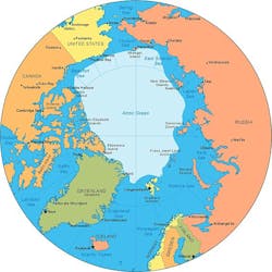
At first glance it might seem absurd that the Arctic could become a focal point in East-West conflict. Viewed from a polar perspective, however, it's clear that the Arctic region is where Russian territory is in closest proximity to several Western countries.
Related: DARPA approaches industry for unmanned sensors to monitor Arctic land, sea, and air traffic
At its closest point, for example, the U.S. state of Alaska is only 53 miles across the Bering Strait from Russia. Across the pole, Canada and Russia are about 2,500 apart -- or about the distance from Los Angeles to Pittsburgh. Increasing access to the Arctic, in fact, soon may force Canada and Russia to negotiate a polar border between their countries.
In the Arctic, the U.S., Canada, Greenland, Iceland, and Norway face-off with Russia over the barren no-man's land of the polar ice cap. Competition among these nations for energy reserves, navigation rights, and a transportation corridor through the sometimes-accessible Northwest Passage are increasing the need for Arctic surveillance technologies to monitor air, sea, and surface traffic that involves military and commercial interests.

Today, however, nuclear-powered submarines capable of polar transit are relatively commonplace. Climate change may be making the Northwest Passage through Canadian territorial waters more feasible than ever before, and promising oil and gas exploration in the Arctic region is sparking international competition. Polar-bordering countries no longer can afford to ignore the Arctic.
The DARPA Future Arctic Sensing Technologies project isn't the only initiative developing Arctic surveillance technologies. Canada and Norway also are at work to keep a close eye on the Arctic region.
Defence Research and Development Canada in Ottawa, the research arm of the Canadian military, is in the midst of an eight-year project called the Northern Watch Technology Demonstration Project to develop a network of satellite-controlled unmanned, semi-autonomous, and remotely controlled Arctic surveillance sensors.
Northern Watch involves unmanned aerial vehicles (UAVs), unmanned surface vessels (USVs), as well as unmanned underwater vehicles (UUVs) to gather data on Arctic traffic and relay it to government information centers for analysis.
The Northern Watch program also involves sonobuoys, bathythermographs, tethered underwater cameras, low-power lasers, and sound velocimeters in support of Canadian intelligence, security, and reconnaissance.
The Norwegian Polar Institute in Tromsø, Norway, is overseeing the Arctic Earth Observation and Surveillance Technologies (Arctic EO) program to develop Arctic surveillance technologies using satellites and UAVs to monitor ship traffic, pollution, and other oceanographic phenomena.
Among the chief technological challenges of these projects are to build electronic and electro-optical sensors able to withstand the severe conditions of the arctic, as well as advanced battery technologies, to enable these sensors to operate unattended for a month or more at a time.
With programs like these in place, the Earth's Arctic regions no longer will be mysterious, forbidding, and inaccessible places, and instead could become crucial focal points for commerce, energy, transportation, and military activities.
