Weather forecasters turn to high technology

From warfighting to civilian airline schedules, weather controls our lives. A sandstorm in the desert or wind shear above an aircraft carrier can bring entire battle plans to a halt. So the modern meteorologist builds forecasting models on powerful computers, and pulls data from radars, satellites, and a global network of sensors deployed on airplanes, weather balloons, and ocean buoys.
By Ben Ames
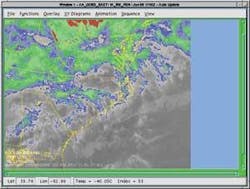
Sitting in a field in Norman, Okla., is a Lockheed Martin AN/SPY-1 radar-the same type of phased-array air-defense radar that is aboard U.S. Navy Ticonderoga-class cruisers and Arleigh Burke-class destroyers.
Yet this one is perched on dry land, thousands of miles from saltwater or, hopefully, enemy aircraft. Instead, this radar finds tornados.
Meteorologists at the National Severe Storms Laboratory-an agency of the National Oceanic and Atmospheric Administration (NOAA)-filter the radar data to find approaching weather hazards.
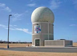
Every second counts when officials are warning residents to find shelter in their basements. Using conventional rotating-dish radars, scientists at the National Weather Service can give an average 10-to-12-minute tornado warning, but the SPY-1 phased-array radar can provide an earlier warning-up to 22 minutes.
Engineers at Lockheed Martin developed the new weather-detection system, called the Tactical Environmental Processor (TEP), as a way to use the existing SPY-1 radars on Aegis vessels for more than just battle management and air defense.
TEP, which uses powerful digital signal processors to filter weather data from the raw radar signal, is a civil and military weather-prediction system that is deployable on land or at sea.
“We focus on multifunctionality, using existing sensors for multiple purposes,” says Tom McNellis, manager of the radar technology program office at Lockheed Martin Maritime Systems and Sensors in Moorestown, N.J.
“The radar’s function is to find aircraft and other threats to the ship, but we pull out what would usually be discarded without slowing its main mission; we can quickly scan the battle area for weather,” he says.
That is important to Navy ships, which today rely on generic weather reports carried on SIPRNet (the Secret Internet Protocol Router Network) if they are close to shore, or by satellite if they are sailing abroad. TEP is an improvement because it generates real-time, localized weather reports, and frees the ships from waiting for broadcast time on overworked satellites in a war zone.
Navy leaders tested the system in 1999 aboard the destroyer USS O’Kane (DDG 77), and in 2000 aboard the cruiser USS Normandy (CG 60). Now they are converting the system to run on open-architecture hardware and software, using commercial off-the-shelf (COTS) components to keep up with technology advances.
For that task, Lockheed Martin engineers chose SMARTpac 600 servers from Sky Computers in Peabody, Mass. Each one carries 20 to 30 digital signal processors on a 6U VME chassis. They use the Infiniband high-speed serial interconnect and Linux-based operating system to achieve an open-architecture design, says Brad Stamp, Sky’s head of business development for military embedded systems.
Lockheed engineers also adopting the system for civilian use, such as the Oklahoma tornado searches. So far, the results are comparable to NEXRAD, the National Weather Service’s “next generation radar” located at 158 spots around the continental U.S. and territories, McNellis says.
TEP works much faster. It completes a weather scan in less than one minute, compared to six minutes for NEXRAD.
NEXRAD, built by Unisys Corp., is a joint effort by the U.S. departments of Commerce, Defense, and Transportation. It uses the Weather Surveillance Radar-1988 Doppler, called WSR-88 in the trade.
NEXRAD’s Radar Operations Center (ROC), also located in Norman, Okla., includes staff from the National Weather Service, Air Force, Navy, Federal Aviation Administration (FAA), and support contractors. Together, they provide centralized support for all WSR-88 systems, from meteorology to software.
As a whole, the network provides early warnings of severe weather and floods for air traffic safety, resource protection at military bases, and management of water, agriculture, forest, and snow removal. For more information, see www.roc.noaa.gov.
Data fusion
Sailors today rely on generic, large-scale weather forecasts. They lack the ability to sample the local environment, fuse that data, or share it with allies. In response, weather researchers at the U.S. Naval Research Laboratory are developing a “nowcasting system.”
Nowcasting refers to current weather and changes predicted over the next six hours, compared to human forecasters who concentrate on large-scale and long-term weather.
Researchers are trying to design a universe of environmental information fused from many sensors and forecasts to maintain a database of the virtual natural environment (VNE). Supporting this effort are researchers at Space and Naval Warfare Systems Command (SPAWAR) in San Diego, as well as NASA and the FAA in Washington.
Nowcast is a network-centric data-fusion system that will allow the forward-deployed battle group to automatically collect meteorological data to analyze the battlespace environment. It will transmit updates continually to warfighters, giving them a common situational awareness.
Managing this project is the Naval Research Laboratory’s Marine Meteorology Division; contractors include Computer Science Corp. (CSC) in El Segundo, Calif., and Science Applications International Corp. (SAIC) in San Diego.
In another effort toward data fusion, NOAA leaders will develop the Advanced Weather Interactive Processing System (AWIPS) that will enable meteorologists to collect observation, sensor, and model data from radar systems, weather satellites, and other modeling systems. They will then use graphic displays and interactive software to process and share the data for weather forecasting and tracking.
One of the bidders is the team of Lockheed Martin Integrated Systems and Solutions in Gaithersburg, Md., and Honeywell Technology Solutions Inc. in Columbia, Md. NOAA leaders are expected to choose a contractor in July for the 10-year, $330 million job.
Remote sensors and weather
One of the main goals of weather researchers is to increase the number of sensors available throughout the atmosphere.
Just 90 weather-balloon sites nationwide are available to collect temperature, wind, and moisture data with twice-daily atmospheric soundings. Now a new initiative will add 1,300 more daily atmospheric soundings in the Great Lakes area alone.
Researchers from NASA’s Langley Research Center in Hampton, Va., have designed a wireless, lightweight weather sensor they will attach to dozens of civilian commuter aircraft.
It is called the Tropospheric Airborne Meteorological Data Report (TAMDAR) instrument, developed at the Georgia Tech Research Institute in Atlanta and AirDat LLC in Morrisville, N.C., for NASA’s Aviation Safety and Security Program. Weighing 1.5 pounds, it measures humidity, wind speed, pressure, temperature, icing conditions, and turbulence. Additional data concerning location, time, and altitude comes from a built-in Global Positioning System receiver.
Researchers chose to attach it to regional jet and turboprop aircraft because they typically fly below 25,000 feet. The TAMDAR sensor allows those aircraft to sense and report atmospheric conditions automatically, then send results via satellite to a ground data center, which processes and distributes weather information to forecasters and pilots.
The Great Lakes Fleet Experiment, started in January, is assessing the performance of the sensor on 64 Mesaba SAAB 340 turboprop aircraft. Masaba Airlines is a regional carrier in Minneapolis. The data the team collects could benefit all weather forecasts and weather forecasting models, because it increases the number of observations in the lower atmosphere.
A large partnership of researchers will analyze the data. Members include: NASA; NOAA; the FAA; AirDat; the National Center for Atmospheric Research in Boulder, Colo.; Massachusetts Institute of Technology Lincoln Laboratory in Lexington, Mass.; Meteorological Service of Canada in Montreal; UK MET Office in London; and Meteorological Network of Europe in Toulouse, France.
The NASA Aviation Safety and Security Program is part of NASA’s Aeronautics Research Mission Directorate. It works with the FAA, aircraft manufacturers, airlines and the Department of Homeland Security to develop technologies to reduce fatal aircraft accidents, and protect air travelers and the public from security threats. For more information, see http://avsp.larc.nasa.gov.
UAVs and weather sensors
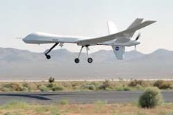
Researchers at NOAA and NASA are working with engineers at General Atomics Aeronautical Systems Inc. (GA-ASI) in San Diego to use unmanned aerial vehicles (UAVs) as weather sensors. This past spring, they were to launch the UAV Flight Demonstration Project, using the Altair, a civilian version of GA-ASI’s Predator B military UAV.
The Altair and its 86-foot wingspan-20 feet wider than the Predator’s-was to carry instruments for measuring ocean color, atmospheric composition, temperature and surface imaging during six flights totaling about 53 hours flight time. The flights, during late April and early May, were to be flown at altitudes as high as 45,000 feet and as long as 20 hours in duration. Controllers were to fly three missions around the Channel Islands area off Southern California, and the rest further out over the Pacific Ocean.
“UAVs will allow us to see weather before it happens, detect toxins before we breathe them, and discover harmful and costly algal blooms before the fish do-and there is an urgency to more effectively address these issues,” says Conrad C. Lautenbacher Jr., the NOAA administrator and under secretary of commerce for oceans and atmosphere. For more information, see http://uav.noaa.gov.
In another example, U.S. Coast Guard leaders announced a plan in February to buy a radar from Telephonics Corp. in Farmingdale, N.Y., a wholly owned subsidiary of the Griffon Corp, to enhance weather prediction in their Deepwater program. Prime contractor Lockheed Martin awarded a $7.3 million contract to Telephonics to build radars for the service’s CN-235 Maritime Patrol Aircraft and HV-911 vertical-takeoff unmanned aerial vehicle.
The UAV will carry a version of the Telephonics’ RDR-1700B lightweight imaging radar, called the RDR-1700CG. Guardsmen will use it for weather avoidance, as well as other tasks like maritime surveillance and search and rescue.
Sensors in space
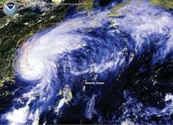
The biggest weather contract now in play is GOES-R, an improvement on the current Geostationary Operational Environmental Satellite (GOES) program.
Managed by NOAA since the 1960s, GOES satellites continuously observe 40 percent of the Earth, including the continental United States. They provide weather monitoring, forecast operations, and a continuous stream of environmental information and severe weather warnings. These satellites provide the weather maps we watch on the nightly news.
The new version will add sophisticated sensors to new spacecraft, including advanced earth imaging, atmospheric sensors, new coastal imaging, lightning mapping, and solar imaging.
Beginning in 2012, GOES-R will become the severe-weather sentinel, providing coastal, oceanic, lightning, and solar observations critical to providing information on impending storms, healthy coasts and oceans, and solar forecasting.
The process will begin when NOAA awards three contracts this fall, worth $30 million each, for preliminary design and risk reduction. Next, the agency will award the largest acquisition contract in its history-exceeding $4 billion.
Under the new strategy, NOAA will be responsible for the GOES-R mission and will partner with NASA to achieve mission objectives. NASA, at the Goddard Space Flight Center in Greenbelt, Md., will supervise the GOES-R flight project, including the command-and-control system, instruments, and spacecraft subsystems on GOES-R and future NOAA geostationary programs. For more information, see http://goespoes.gsfc.nasa.gov or www.nesdis.noaa.gov.
“With recent advances in space-based observing technology, we are pushing beyond weather and turning the GOES-R platform into a more encompassing environmental observational satellite that will benefit multiple sectors of the economy,” says NOAA’s Lautenbacher. “Each GOES-R series satellite will bring greater capabilities, and will be a key contribution to the emerging Global Earth Observing System of Systems.”
Computers handle the data
As researchers collect data to improve their forecasts, they will quickly overwhelm their current computers. Modern weather forecasting demands huge computational power, and the problem gets worse as scientists try to make forecasts farther into the future or for a more specific physical region.
The challenge is even harder for military users because not all weather forecasts are the same. Pilots need to know the forecast for high altitudes and large ranges, while sailors need to know sea conditions for smaller ranges, and soldiers need to know ground-level weather for extremely local ranges.
Engineers at the U.S. Army’s High Performance Computing Research Center in Adelphi, Md., are looking for a solution.
“We focus on using high-performance computing systems to run numerical weather prediction models to ascertain what improvement in forecast we can achieve by running them at high resolution, and validate our model results with observations,” says Edward Colon, a staff scientist in atmospheric science for Network Computing Services, Inc. (NCS) in Minneapolis. He is assigned to the Army High Performance Computing Research Center.
“We are now working with a group at White Sands Missile Range, using MM5, the old operational model used by the Air Force Weather Agency. We are running it at high resolution and nesting forecast domains to cut down on computational costs.”
MM5 is accurate to a resolution of 18 square kilometers, but Colon’s group is running a version at 10 kilometers for operational studies, and 5 kilometers for research models. They also use finer resolution in the vertical dimension, and they use more time steps-modeling changes eight times per minute instead of four times.
Those changes have an enormous effect on the computational load.
“People can use their PC or laptop for coarse resolution. But when you get below 10 kilometers or 5 kilometers, it requires a large number of computations. And you must complete it within three hours to be useful. So the only tools available are HPC machines, using advanced interconnects to link a large number of processors and storage,” says Tony Meys, a support specialist for atmospheric science, also assigned by NCS to the Army job.
Since March 2003, the researchers have used the X-1 computer from Cray Inc. in Seattle. They recently doubled its computing power by upgrading to the Cray X-1E.
The system uses Cray’s proprietary interconnect to tie together thousands of processors. It is similar to a typical cluster, but offers better bandwidth and latency than commercial interconnects like Myrinet or Gigabit Ethernet, says Paul Muzio, vice president of government programs for NCS, and the support infrastructure director for the Army High Performance Computing Research Center.
A system that big uses tons of data. A recent simulation covered a 500-by-500- kilometer area at one-kilometer resolution. The researchers outputted data every hour, collecting 250 gigabytes in total, Colon says.
To handle that much data, they send it to disk initially, and then migrate it to tape for long-term storage. The Cray system is designed to handle the load-it can hold 50 terabytes of data on its disks.
These experiments are still in the laboratory; the U.S. Army depends on Air Force forecasters for all its data. Still, soldiers need more data about the ground surface than pilots do.
For example, water trapped in the ground will evaporate as the sun shines on it throughout the day. If a low-pressure zone enters the area, it could attract moisture and cause fog that affects visibility, communications, optical systems, and remote sensors. Forecasting is also difficult for soldiers since they may not be able to place sensors in hostile territory.
Software makes fast forecasts
Another way to handle massive amounts of data for weather forecasting is to automate human tasks with more efficient software.
Airports around the country pull forecasting data from the National Weather Service’s Terminal Aerodrome Forecast, called TAF. Every six hours, it paints a detailed picture of the local cloud ceiling, visibility, wind, lightning, and precipitation.
Now engineers at Harris Corp. in Melbourne, Fla., have created a system that delivers the same information every hour, without relying on human forecasters. It is called FuzzyTAF, because it uses algorithms based on a form of artificial intelligence called fuzzy logic, says Tom Hicks, principal investigator for Weather & Information Technologies research at Harris.
The system has compared well to human forecasts over the past four years, and has outperformed them in the past year, he says.
“This offers the potential to forecast for many more airports than NWS has manpower to cover today. NWS just doesn’t have the manpower to triple or quadruple the number of forecasts it puts out,” he says. “Anyway, an automated forecast that is less than an hour old will usually outperform an NWS forecast that could be six hours old.”
The system draws data from the same source as human forecasters; a combination of sensors, human observers, and numerical models run by the National Weather Service. The system is still in development, but Harris hopes to eventually sell it to the FAA.
“The FAA has expressed a need for timely forecasts, in fractions of an hours instead of multiples of hours, and that doesn’t mesh with current forecast system used by NWS,” says Hicks.
FuzzyTAF does not need much computer power to generate its forecasts, since NWS staff handles most of that work in creating its models.
Fuzzy logic is a branch of artificial intelligence that applies logic to variables that may be somewhat fuzzy, he says. That means it could classify a half-full glass of water in two ways. It would call it “full” to the degree of 0.5, and also “empty” to a degree of 0.5. Traditional algorithms cannot place a single datum in two different sets.
“More traditionally, you would use multiple linear regression. But this uses less math, so it’s free from the limitations of pure statistical processing,” he says.
So FuzzyTAF can run on a typical dual-processor desktop PC. It downloads data over the Internet or satellite, at a rate of 50 to 60 megabytes per hour. Then it generates forecasts for 1,400 locations around the country, and renews them every hour.
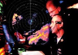
Since 2003, FAA forecasters have used another Harris tool-the Weather And Radar Processor (WARP). WARP feeds real-time graphical weather data directly to computer terminals in the agency’s 21 Air Route Traffic Control Centers. That is a great improvement over the time when controllers had to read pages of alphanumeric data to get the same NEXRAD reports.
The system also uses software tools to consolidate weather data from several sources into a single, integrated display.
Engineers at Harris’ Government Communications Systems Div. started designing the system under a $131 million contract in 1996. And this April, Harris won a 54-month, $57 million extension of the contract, to provide software and hardware through the life of the project.
