Navigation and guidance meets sensor fusion
Knowing where you are and where you are going no longer involves only the Global Positioning System (GPS); systems designers are integrating a growing number of sensors and data-fusion algorithms to create fool-proof, jam-proof, real-time positioning information.
By John Keller
Navigation and guidance throughout history has always involved piecing together information from a variety of sensors. In the era of tall ships, when the world was flat, navigation involved a sextant, a compass, an hourglass, and a rope with knots tied at intervals. For their day, these tools did a fine job of determining position, heading, and speed—as determined by distance traveled over time.
Today navigation involves many of the same principles, yet the sensors involved have made quantum leaps in sophistication, and the number of sensors being integrated into navigation systems continues to grow.
Modern navigation systems have replaced the sextant, compass, hourglass, and rope with the satellite-based Global Positioning System (GPS) and inertial measurement units (IMUs) based on a variety of optical and mechanical gyros. More sensors are being added all the time, not only to enhance navigational precision, but also to compensate for the blockage or jamming of GPS signals, and the drift-over-time errors of all inertial systems.

With a growing number of sensors is coming an increasing sophistication in the software algorithms that stitch together information from all the sensors to yield precise positioning information, no matter how quickly one is moving, at what altitude he is operating, how rugged the terrain, or how severe the electromagnetic interference.
Finding yourself
Throughout the ages, many of the laws of navigation have remained constant. Perhaps the most fundamental of these laws is the use of some sort of triangulation to determine one’s location in the world. This was as true in the days of the sextant as it is in the modern era of GPS.
To determine his position, the navigator needs at least two known points. These known points could be prominent visible landmarks, the sun or a star and the horizon, or two GPS satellites. The navigator determines a bearing to each point and draws a line along the two bearings. Where the lines intersect is his position.
Using a sextant, for example, the known position of the sun—as determined by date and time of day—and the horizon are the known points. The instrument measures the angle between itself, the sun, and horizon to determine its position—or the third point of the triangle.
Similarly, a boat navigator along the coast can take a compass heading of two known points visible on land—distinctively painted lighthouses or well-known landmarks, for example—and draw lines along those headings. Where the lines intersect on the nautical chart is the boat’s position. Determine the boat’s position in this way twice exactly an hour apart, and the navigator can determine the boat’s speed as distance over time.
The GPS satellite constellation working together with a GPS receiver basically does the same thing, although it automates the steps and determines position in real time. It measures the position of a GPS receiver relative to two or more orbiting satellites whose positions are precisely known.
In addition, each GPS satellite has a precise timing device like an atomic clock. With the added dimension of time, the GPS system can determine the bearing and speed of a moving GPS receiver. With several satellites in view, the GPS receiver also can determine its altitude and rate of climb and dive.
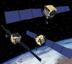
Global Positioning System
The GPS system is a sophisticated way of determining position, speed, direction, and altitude, but navigating by triangulating radio-frequency (RF) signals is not new. Virtually since the days of Guglielmo Marconi at the dawn of the 20th century, navigators have been triangulating the signals from at least two known transmitters to determine their positions.
In the early 20th century, ship and aircraft navigators could determine their positions if they could receive signals from two commercial radio stations. They could determine their bearings from the radio stations using automatic direction finding (ADF) equipment, and determine their positions on the aeronautical charts by triangulation.

Later, pilots could more precisely determine their locations by triangulating the signals from two VHF omni-range (VOR) navigation beacons, which send out tight radio signals, or radials, on every point of the compass. Mariners operating in coastal waters have done much the same thing with the Loran and Omega systems. It all boils down to triangulating from two known points.
Today GPS is becoming the dominant navigation system for ships, land vehicles, hikers, bikers, and aircraft. Military forces are even using GPS to guide smart munitions to their targets. It makes sense that GPS has become so popular. It is accurate roughly to about 10-to-30 feet, which for most applications is just fine.
It did not used to be this way. Until mid 2000, the U.S. military introduced intentional errors in GPS satellite signals, which blurred the accuracy of commercially available GPS receivers to about 30 to 300 feet. At that time, only special military GPS receivers with decoding technology were able to remove the errors for high accuracy.
No so today. The military turned off the GPS signal errors in 2000 as commercial business and transportation came to rely ever more heavily on GPS, and aviation officials started eying satellite navigation for high-precision tasks like instrument landings.
GPS in aviation
With its enhanced accuracy, the growing popularity of GPS in aviation navigation comes at the perfect time, considering rapidly rising costs of fuel.
Before GPS, aircraft pilots navigated by flying from VOR beacon to VOR beacon along a so-called system of Victor Airways. Rarely, if ever, are VORs arranged in straight lines between aircraft destinations, so airplanes essentially had to fly a jagged line between airports.
GPS air navigation, however, is different. It enables pilots to fly directly to their destinations in straight lines. It might sound like a minor point, but enabling commercial airliners to fly directly to their destinations saves fuel, reduces pollution, and can help increase air traffic volume.
With GPS, air traffic controllers can fit more aircraft in tight air spaces, and can fly aircraft more closely spaced on popular air routes—particularly over the world’s oceans where pilots can be out of range of radio contact.
Pilots still use the old VORs as backup, and general aviation aircraft without GPS capability still use VOR-based navigation, or simply can fly landmark-to-landmark if weather conditions allow.
“Navigation is an enabler for most of the things we would like to accomplish in commercial aviation,” says Jeff Peterson, vice president of navigation and sensors at integrated navigation system designer Honeywell Aerospace in Minneapolis. “It helps us manage air space better, increases traffic, and reduces greenhouse gases. The focus is on greater accuracy combined with high integrity.”
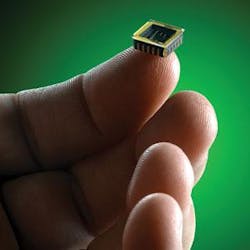
Miniature GPS receivers
Advances in electronics also helps engineers develop GPS receivers that are as small as computer chips, which means that GPS capability can be embedded into systems like smart munitions, unmanned aerial and ground vehicles, cameras and other sensors, and even shipping containers.
“Moore’s Law has helped guidance enormously, because these things are smaller and lower cost,” explains Lowell Buchholz, business development manager for precision engagement at Rockwell Collins in Cedar Rapids, Iowa.
Rockwell Collins is involved in developing sophisticated navigation systems, avionics, and GPS satellite payloads. Moore’s Law, which pertains to Intel co-founder Gordon E. Moore, refers to trends in computer hardware that enables scientists to double the number of transistors on a device about every two years. This trend leads to faster, smaller, and more powerful electronic devices.
“As these digital processing improvements occur, it becomes easier to integrate these GPS technologies into small and more affordable products,” Buchholz says. He points out that GPS receivers are starting to go into radios, tablet computers, and other portable devices.
Buchholz specializes in precision weapons such as cruise missiles and smart artillery rounds. “That market space is growing rapidly because GPS technology is becoming smaller and more affordable,” he says. “There are a variety of guidance techniques that can be applied to weapons and other low-cost applications.”
GPS blackouts
Yet even though GPS is one of the most accessible and accurate navigation systems, its reliability is questionable in wartime when enemies or even the U.S. military could jam, scramble, or distort the signals to deny their use to adversaries. Mountainous terrain also can mask GPS signals, and the insides of buildings, tunnels, and caves can compromise navigational signals. Also, consider the submarine that must operate submerged and stealthy for long periods of time without access to GPS signals.
What to do then?
Well, consider the ancient mariners once again. They did not rely only on sextants, but used these instruments together with compasses, time pieces, and knotted ropes—blending information from several different sensors. It is not likely that the ancient ocean mariners realized they were among the first to put sensor fusion into practice.
Fast forward to the present day. Have an unreliable intermittent GPS signal? Then blend its information with other sensors to correct for errors, or simply go to other navigational sensors until a reliable GPS signal is available again.
It has become commonplace in high-performance aircraft, land vehicles, ships, and submarines, for example, to combine GPS and inertial measurement units in one system that uses the strengths of each sensor to compensate for the weaknesses of the other. One of the big differences between the two: inertial systems are immune to electromagnetic interference, while GPS is not.
An inertial navigation system uses gyros based on optical, spinning-mass, or microelectromechanical systems (MEMS) technology. This kind of sensor can be exceedingly accurate for as long as several hours after it begins operating; over short periods of time it can be even more accurate than GPS, yet every inertial measurement unit will drift over time and introduce larger errors the longer it operates on its own.
Blending sensors
Combine GPS and IMU, and the GPS can periodically update the IMU and correct for the inertial system’s drift. Enter an area of GPS jamming, and the IMU can probably handle navigation and guidance tasks during the time the GPS is unavailable.
Honeywell scientists are working on a program called HIGH—short for Honeywell IRS/GPS Hybrid (IRS stands for inertial reference system and refers to gyro-based technology)—to develop precision navigation systems suitable for commercial aircraft navigation.
Commercial aircraft navigation systems refer to required navigation performance, or RNP, which refers to navigation errors of no more than 0.1 nautical miles per hour.
“Inertial reference is immune to outside interference, but drifts over time,” explains Honeywell’s Peterson. “Combine those two technologies, however, and we are able to achieve this 0.1 RNP accuracy worldwide 100 percent of the time. Increased accuracy enables you to fly preferred routes, have quicker access to airports, and use less fuel. We are achieving that through combining GPS and INS into one system.”
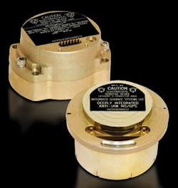
Rockwell Collins and Honeywell Aerospace are also are collaborating on a joint venture called Integrated Guidance Systems—IGS for short—that blends miniature GPS receivers with MEMS-based inertial measurement units to create miniature integrated navigation and guidance systems for embedded applications like precision weapons.
The program “allows us to do more physical and functional integration than either company could do by itself, which will further reduce size and cost,” says Rockwell Collins’s Buchholz. “We collaborate to integrate military GPS and MEMS navigation systems.”
Embedding integrated navigation and guidance systems in portable electronics like radios and hand-held computers “provides the user with better situational awareness—or personal awareness—to help you stay out of harm’s way, and better locate your target to reduce fratricide,” Buchholz says.
Modern navigation and guidance, however, does not stop at blending GPS and inertial nav. Systems integrators are looking into ways of combining radar, visible-light cameras, infrared sensors, radio beacons, and sonar systems to augment GPS and IMUs.
Researchers at Honeywell Aerospace are considering technologies that could blend into precise navigation and guidance aids in environments where GPS is wholly denied. “We are using TV, radio signals, and video to get rates of movement and closure rates to combine into a system that gives you accurate navigation without GPS,” says Honeywell’s Peterson. “Those are future technologies that are being addressed.”
“We are considering laser radar for a lot of the GPS-denied environments where users are in physically constrained environments or even indoors,” explains Earl Benser, director of advanced sensors and microsystems at the Honeywell Aerospace Advanced Technology Group’s research technology sector in Plymouth, Minn.
“We want to be able to provide navigation aids where GPS signals are not available,” Benser continues. “We will look at signals of opportunities, such as VORs, Loran, and cell phone towers to develop robust navigation capability where you take whatever you can get to augment your inertial navigation suite.”
GPS modernization: get ready for even better accuracy
The U.S. satellite-based navigation aid called the Global Positioning System (GPS) is on the verge of a multi-frequency modernization that promises not only to increase accuracy for military and civilian users alike, but also to enhance military GPS security against inadvertent interference and enemy jamming.
Modernization efforts, which should be completed by around 2015, will add new signals to the GPS system to give military and civilian users access to two GPS signals, rather than just one.
“A two-frequency or multifrequency approach does measurements on both frequencies and can correct for atmospheric errors in the signals,” says Lowell Buchholz, business development manager for precision engagement at Rockwell Collins in Cedar Rapids, Iowa.
The additional signals, he says, will improve GPS accuracy from tens of meters down to meters, or perhaps even to centimeters for survey applications.
The new military signals, called the M code, will operate on the edges of existing GPS signals, with only minor signal overlap. Military signals will use sophisticated anti-jam and signals security to prevent signal degradation, distortion, or denial from enemy electronic warfare.
A new dedicated civil signal, meanwhile, will give civil users full dual-frequency service. Farther in the future, another frequency will be dedicated to high-accuracy use for aviation.
“There is a great deal of action in GPS modernization,” Buchholz says. “Rockwell is working on that to define secure military GPS that is capable of using the new signals, as well as the legacy signals, in an integrated package, for better integrity, better accuracy, and resistance to jamming.”
Additional accuracy to the GPS signals will enable new applications in precision guidance, such as enabling a wide variety of unmanned aerial vehicles to use aerial refueling to keep themselves on station for very long missions.
For military users who must deal with GPS signal interference and jamming, “multiple frequencies can enable users to switch away from the jammed signal to one that is clear,” Buchholz says. “For widespread jamming, there are ways to use multiple approaches in an array, calculate time of arrival, and do digital or analog nulling of those signals.”
In addition, Buchholz says industry scientists are looking into ways of using available non-GPS signals of opportunity to correct or augment the GPS.
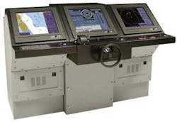
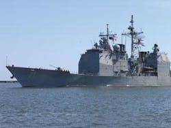
Military and commercial maritime shipping moves to electronic charting and navigation
Blending a growing number of guidance sensors is at the heart of a major trend in military and commercial maritime shipping that is discarding reams of paper nautical charts and substituting sophisticated electronic charting technology.
“The goal is eventually to replace paper charts on all U.S. Navy ships and submarines, and navigate by electronic chart displays,” says Jeff Holloway, director of business development, marketing, and sales of U.S. defense and homeland security at the Sperry Marine business unit of Northrop Grumman Corp. in Charlottesville, Va.
The U.S. Navy has certified Sperry Marine’s Electronic Chart Display technology for seven different surface ships and five submarines, Holloway says. Many commercial ships also are going to electronic charting, which displays the ship’s position relative to nearby maritime traffic, hazards, and land masses on electronic displays.
One of the most notable features of electronic chart technology is its ability to combine information from the satellite-based Global Positioning System (GPS), as well as from radar ranging, bottom-sensing sonar, and even from compass headings and sextant fixes.
Traditional maritime navigation methods require navigators to obtain fixes, and plot the ship’s position on a paper chart. “A position fix tells you where you were at the time of the fix, and you have to apply dead reckoning techniques to determine your current ship’s position—which is especially critical in restricted waters,” Holloway says.
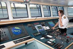
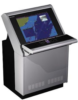
Electronic charting uses GPS as its primary sensor input, yet is able to process inputs from a wide variety of backup navigational sensors, such as inertial sensors, depth detectors, visual bearings, and speed sensors. The system also accounts for the individual vessel’s turning characteristics and turn rates.
“The software has functionality where you can project your track based on the effects of wind and current, as well as the turning characteristics of your ship,” Holloway says. “Should the ship be equipped with an autopilot and the system is engaged with the Integrated Bridge System, the track-control steering capability compensates for set and drift, and will adjust your ship’s course if necessary without any human intervention.”
Electronic charting, furthermore, will overlay the ship’s current positioning information with a radar overlay that indicates surface contacts and nearby land masses. It also can incorporate information from commercial automatic identification systems that identify other ships by name, course and speed, name of the captain, and the national flags they are flying.
“Using inputs from an Automatic Identification System (AIS), surface contacts appear on the display and allow a mariner to identify the vessel by name, registry, course, speed, and additional ship-specific information and thus, are not simply displayed as an unknown radar contact,” Holloway says.
A key advantage of electronic charting technology is the extra time it gives to the ship’s crew to avoid hazards and respond to emergencies. “As a bridge watchstander, it gives you more time to assess your situation,” Holloway says. “As the officer of the deck, your head is up. It improves situational awareness, and gives you more time to make a decision, rather than doing manual requirements of navigation and contact management and avoidance, thus allowing the bridge watchstander more time to safely and efficiently maneuver the ship.”
For the future, Sperry Marine engineers are looking into incorporating electro-optic sensors into electronic charting systems, such as infrared sensors or new generations of 360-degree visual-light sensors.
