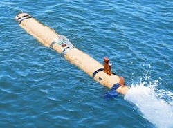
POCASSET, Mass., 19 July 2012. Researchers at the University of Maryland's Horn Point Laboratory in Cambridge, Md., needed an autonomous underwater vehicle (AUV) to help oceanographers advance the study of coastal ocean environments. They found their solution from unmanned underwater vehicle (UUV) specialist Hydroid Inc. in Pocasset, Mass.
The Horn Point lab, part of the University of Maryland's Center for Environmental Science, has purchased one REMUS 600 system for shared research in studies of coastal and near coastal environments. The U.S. Navy also relies on the REMUS UUV design for mine-hunting operations. Horn Point will take delivery of the UUV in March 2013. REMUS is short for Remote Environmental Measuring Units.
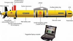
The REMUS 600 is about 16 feet long depending on its sensor payload configuration, weighs 530 pounds, and is slightly wider than one foot in diameter. It has a 5.2-kilowatt-hour rechargeable lithium ion battery that enables the UUV to operate for as long as 70 hours. It has a DC brushless motor and two-bladed propeller. It can travel at speeds of about 5 knots to depths of 1,970 feet. Hydroid is a subsidiary of Kongsberg Maritime.
Not only will the UUV help researchers diagnose the health of the Chesapeake Bay, but the marine robot also will be available as a shared resource for scientists to use in coastal environments around the world. It also has educational potential and can serve as a window to the sea for school children, teachers, and the general public.
Most of the knowledge of the Chesapeake Bay is from bi-weekly cruises along its main axis. Data is collected either by instruments put in the water or by attaching monitors to fixed buoys and platforms. Both approaches have drawbacks that the REMUS 600 UUV helps address, lab officials say.
The REMUS 600 can operate closer to the bottom, in adverse weather conditions, and with greater flexibility than is now possible with surface-based observations. This will enable scientists to observe how circulation, chemical constituents such as dissolved oxygen and nitrate in the water, and marine animals like phytoplankton and zooplankton interact as part of the marine ecosystem.
The lab's REMUS 600 UUV will be outfitted with several state-of-the-art technologies to enable a wide variety of research tasks, lab officials say. "The reason we picked the REMUS 600 specifically is the modular capabilities the vehicle offers," says Nick Nidzieko, coastal physical oceanographer and assistant professor at the University's Center for Environmental Science.
The lab's REMUS 600 will include forward and aft hovering modules, which enables the UUV to hold position in one location above the sea floor; a second on-board payload computer that helps users implement autonomy algorithms they develop; and a nitrate sensor enabling real-time measurements of a critical element in oceanographic research.
The UUV navigates underwater with an advanced inertial navigation system coupled to an acoustic device that can be programmed with an initial set of waypoints and travel speeds. Once it finds its target, it can autonomously adapt its measurement protocol via a second computer that constantly monitors the data stream, including salinity, temperature, oxygen, nitrate, and flourescence -- an indicator of the presence of phytoplankton.
Story continues below
Cross section of the Hydroid REMUS 600 UUV.
Missions can be redirected via satellite communication when the vehicle is at the surface, or with an acoustically relayed message via surface buoy. "This piece of equipment is a game changer for coastal oceanographic research," Nidzieko says. "This technology is going to be an essential part of the way we approach questions about the marine environment in the future."
Forward and aft thrusters on the REMUS 600 enable the vehicle to hover, pivot, and vertically profile. "It's amazing; you can put this UUV in all these places and generate an incredibly rich data set that will open up ways of thinking about oceanographic research," Nidzieko says.
Planned projects at the lab include studies of frontal dynamics at the continental shelf-slope break, sediment trapping mechanics in the Hudson River, autonomous hypoxia mapping in the Chesapeake Bay, and acoustic imaging studies of zooplankton.
Horn Point Laboratory leaders say they plan to make the REMUS 600 system available for charter to other researchers in the marine sciences industry. While under charter, Horn Point's UUV technician will serve as the UUV's skipper to enable groups with limited experience to use the UUV safely to its maximum potential.
The REMUS 600 uses a vehicle interface common to all REMUS UUVs, which handles vehicle maintenance, checkout, mission planning, and data analysis.
Standard sensor payloads for the REMUS 600 are acoustic Doppler current profiling; inertial navigation system; pressure; conductivity and temperature; depth; and Global Positioning System (GPS). The UUV also comes with an acoustic modem; Iridium communications; and WiFi communications.
Optional sensors include dual frequency side scan sonar; synthetic aperture sonar; eco sensors; video camera; acoustic imaging; electronic still camera; single frequency side scan sonar; and sub-bottom profiler.
Typical missions for the REMUS 600 include hydrographic surveys; mine countermeasures; harbor security; environmental monitoring; debris field mapping; search and salvage; fishery operations; and scientific sampling and mapping.
Follow Military & Aerospace Electronics and Avionics Intelligence news updates on Twitter


