Headwall Photonics chooses remote-sensing software from ReSe for Hyperspec hyperspectral imaging sensors
FITCHBURG, Mass., 7 June 2012.Airborne reconnaissance sensor designers at hyperspectral sensor imaging specialist Headwall Photonics in Fitchburg, Mass., needed commercially available remote-sensing software to offer users a complete airborne hyperspectral imaging sensor system. They found their solution from ReSe Applications Schläpfer in Wil, Switzerland.
Headwall designers are combining their company's Hyperspec airborne hyperspectral electro-optics sensors with PARGE remote-sensing software from ReSe, which provides orthorectification and direct geocoding for airborne imagery data acquired with Headwall's hyperspectral imaging sensors. PARGE stands for Parametric Geocoding & Orthorectification for Airborne Optical Scanner Data (story continues below).
Headwall engineers will use the ReSe remote sensing software to complement the company's family of Hyperspec and Micro-Hyperspec airborne imagers, says David Bannon, chief executive officer of Headwall. The Micro-Hyperspec imaging sensor is particularly useful for robotics and small unmanned aerial vehicles (UAVs), Headwall officials say.
"The software capabilities offered by ReSe Applications are important to provide complete imagery solutions for hyperspectral data sets," Bannon says.
PARGE software provides a reconstruction of the scanning geometry of airborne data cubes pixel-by-pixel, using the position and attitude of the airplane. It can be used together with terrain elevation data.
PARGE performs an ortho-rectification of line-scanner imagery using a digital elevation model based on precise flight parameters such as GPS position and attitude angles. Combining digital elevation models and optional ground control points can achieve sub-pixel geometric accuracy.
PARGE is suited for the correction of all kinds of airborne scanner imagery and is optimized for airborne hyperspectral instruments, ReSe officials say.
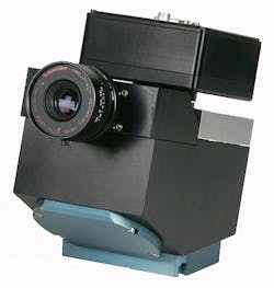
Headwall's Hyperspec sensors are deployed for commercial and civilian remote sensing applications. The sensors use aberration-corrected reflective Hyperspec design for spectral and spatial imaging performance with a wide field of view for flight swath efficiency, Headwall officials say.
For more information contact Headwall Photonics online at www.headwallphotonics.com, or ReSe Applications Schläpfer at www.rese.ch.
