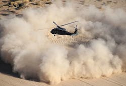
Sierra Nevada demonstrates helicopter synthetic vision for degraded visibility environments (DVE)
Officials of the Aviation and Missile Research, Development and Engineering Center (AMRDEC) at Redstone Arsenal, Ala., are working with avionics designers at Sierra Nevada Corp. in Sparks, Nev., to develop and demonstrate degraded visual environment (DVE) technologies to mitigate the effects of brownout or whiteout conditions on helicopter pilots.
Landing a helicopter in choking dust or blinding snow can be particularly difficult because pilots can become disoriented easily near the ground as they lose view of the horizon and other visual cues.
Sierra Nevada engineers recently displayed advancements in the company's synthetic vision technology during demonstrations at the DVE Mitigation (DVE-M) program’s NATO Yuma Flight Trials in Yuma, Ariz., company officials say.
The DVE-M program is a multi-year U.S. Army research effort to ground and flight test sensor, flight control, and cueing technology combinations to provide helicopter pilots with visual awareness in DVE environments such as brownout conditions.
Brownout from dust and whiteout from snow are particularly dangerous for helicopter pilots because without help pilots can lose track of the horizon during critical moments in takeoff and landing. This can cause pilots to roll the aircraft while close the ground, which risks hitting the rotors on the ground or other nearby objects.
For the DVE-M program, Sierra Nevada engineers are focusing on real-time fusion of multi-sensor data from millimeter wave radar, light detection and ranging (LIDAR) sensors, infrared cameras, and various a-priori digital terrain data, company officials say.
During recent tests at Yuma Proving Ground Sierra Nevada’s DVE technology enabled pilots to conduct more than 86 safe approaches to hover and landing in dust and heavy brownout conditions.
Next February Sierra Nevada will demonstrate company DVE technology again at the European NATO DVE Flight Trials, focusing on additional degraded visual conditions involving fog, rain, sand, and snow.
Applicable to helicopters and fixed-wing aircraft, Sierra Nevada’s DVE solutions provide increased flight safety and operational capability for all modes of flight in natural and aircraft-induced DVE by restoring pilot situational awareness through real-time, multi-sensor fused imagery, company officials say.
In mid-2013 the Aviation Applied Technology Directorate of the Army Research, Development, and Engineering Command at Fort Eustis, Va., awarded a contract to Sierra Nevada to integrate and test the company's Helicopter Autonomous Landing System (HALS) aboard an Army UH-60A/L helicopter as part of the AMRDEC DVE-M program.
The Sierra Nevada HALS helicopter avionics uses a 3D image-rendering 94 GHz pulsed radar, global positioning system (GPS), inertial sensors, and cockpit displays to help helicopter pilots view geographic features outside the aircraft during brownouts and whiteouts from dust, snow, or other visual impairments.
The HALS system uses radar data translated to color graphic representations on cockpit displays to help helicopter pilots control the aircraft's roll, pitch, and yaw based on radar-generated graphic representations of the ground and nearby geographic features in zero-visibility conditions.
The HALS avionics enables helicopter pilots to take off, land, and fly in all degraded visual conditions, provides visual situational awareness to enable pilots to see and avoid wires, cables, and terrain, and well as follow landmarks in poor visibility.
The system also includes Brownout Symbology Software (BOSS), precise guidance to landing in zero visibility, and safe transition from visual to instrument flying conditions.
For more information contact Sierra Nevada Corp. online at www.sncorp.com, or the Army AMRDEC at www.army.mil/info/organization/unitsandcommands/commandstructure/amrdec.
Learn more: search the Aerospace & Defense Buyer's Guide for companies, new products, press releases, and videos
