Military GPS jammer tests could knock out satellite navigation to much of West Coast
These tests on six Tuesdays and Thursdays this month -- from 9:30 a.m. to 3:30 p.m. pacific daylight time on 7, 9, 21, 23, 28, and 30 June -- have the potential to disrupt satellite navigation aboard commercial passenger jets departing and arriving busy West Coast ports of entry such as Los Angeles and San Francisco international airports.
During these hours commercial and general-aviation aircraft may have to revert to legacy aviation navigation systems involving VHF and medium-frequency radio beacons that send signals to cockpit avionics called VHF Omnirange (VOR) and automatic direction finder (ADF) indicators.
Officials of the Federal Aviation Administration (FAA) in Washington have sent out an Notice to Airmen (NOTAM) flight advisory warning of the potential GPS disruptions to aircraft on six days this month.
These military tests, being conducted at or the China Lake Naval Air Warfare Center in the desert town of Ridgecrest, Calif., "may result in unreliable or unavailable GPS signal," the FAA advisory warns.
Related: Raytheon joins L-3 in program to speed modern anti-jam GPS receivers to the warfighter
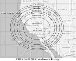
GPS signals for aircraft flying at 25,000 feet could be disrupted or knocked out during testing in an area that includes major airports in Los Angeles, the San Francisco Bay Area, San Diego, Phoenix, and Salt Lake City.
It's not just aircraft navigation that could be affected. Land vehicles, boats, and surface ships could have diminished GPS capability in a 235-nautical-mile radius from China Lake, which includes the ports of Los Angeles, Oakland, and San Diego.
Cars and trucks trying to use GPS to get from point A to point B during those times also could be out of luck. The .pdf FAA advisory, with a map of potential GPS outages, is available online at https://www.faasafety.gov/files/notices/2016/Jun/CHLK_16-08_GPS_Flight_Advisory.pdf.
Details about the military GPS jamming tests are few, yet it begs the question: what's worth knocking out GPS navigation in more than half the West Coast's major metropolitan areas?
Related: Air Force accelerates program to provide M-Code GPS receivers to warfighters worldwide
The potential for electronic warfare jamming that can knock out satellite navigation over wide areas is a very real threat. the potential effects of GPS jamming isn't widely known, yet the threat gets bigger the more we rely on GPS.
Twenty years ago no one gave GPS much thought. Today it's standard with about any smart phone. I know plenty of drivers who couldn't live without it. Learning to use the venerable Rand McNally road atlas is a low priority today.
Trucking and shipping companies, moreover, use GPS to track their fleets, and the global air traffic control system is in the process of moving exclusively to GPS for fast and efficient air transport. Where would we be without it?
For a lot of vehicle drivers, airline pilots, and ship captains on the West Coast, they're finding out this month. Let's hope the test data we get from these tests will be worth the short-term inconvenience.
