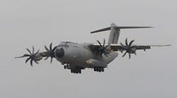
Military Airbus A400M airlifter to be outfitted with Goodrich terrain-referenced navigation system operating independently of GPS
"Goodrich's TERPROM system will provide the A400M with a battle-proven TRN capability that has been specifically designed for tactical transport operations,” says Daniela Dudek, A400M military mission management system program head, Cassidian Electronics. “It will greatly enhance the situational awareness of the A400M crew, allowing them to operate with increased safety at low level, in poor conditions, or when GPS is denied."
The TERPROM TRN system will be embedded inside the A400M military mission management system, which is developed by Cassidian Electronics, EADS.
"Integration of the TERPROM TRN system onto the A400M confirms the real benefits this system offers to military aircraft crews in today's intense operational scenarios,” admits Martin Couch, avionics business director for Goodrich's Plymouth team. “The TERPROM system is highly accurate, passive, and can be implemented in a wide variety of ways to suit different operational requirements and aircraft types."
The TERPROM software-based system references the actual terrain over which the aircraft is flying. It draws and combines information from the aircraft's radar altimeter and inertial navigation system with a digital terrain database, to provide accurate terrain-referenced navigation and situational awareness, even in areas where GPS is not available. Its TRN capability calibrates errors within the aircraft inertial navigation system to provide a navigational accuracy of 15 to 30 meters.
The system can be used for predictive ground collision avoidance, to enable more accurate terrain following flight, for wire and obstacle warning and cueing, and for passive target ranging.
