NASA asks industry about plans for Landsat Next Earth-observation satellite with advanced imaging sensors
GREENBELT, Md. – U.S. space experts are asking industry to weigh-in on plans to build and launch a next-generation Landsat Earth-observation imaging satellite in the late 2020s with enhanced sensor capabilities.
Officials of the U.S. National Aeronautics and Space Administration (NASA) Goddard Space Flight Center in Greenbelt, Md., issued a request for information (RFI2020LandsatNext) on Tuesday for the Landsat Next project, which by late this decade is expected to offer sensors for superspectral land observations with high-spectral and high-resolution imagery of the Earth's surface.
These improved Earth images are to be for agricultural monitoring, ecological monitoring, urban studies, water resources management, and related applications. Sharing a role in the Landsat Next project is the U.S. Geological Survey (USGS) in Reston, Va.
In addition to enhanced imaging capability, the Landsat Next project also is expected to offer users more frequent satellite coverage -- at least once every eight days, NASA officials say.
For the past 48 years, Landsat satellites and ground sites have made available global multispectral Earth images of 15-to-120-meter resolution for research on land use change, forest health, carbon inventories, and changes to Earth's environment, climate, and natural resources.
Researchers in government, academia, and industry use Landsat data for resource issues like water resource management, wildfires, agricultural productivity, rangeland management, and understanding impacts of climate variability on ecosystems.
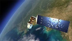
The USGS today operates two spacecraft, Landsat 7 and 8, which NASA developed. Landsat 9, a near copy of Landsat 8, is under development, and is expected to begin operations in 2021. Together these satellites can cover the entire Earth's surface every 16 days.
Landsat 8 and 9 each host two instruments: the Operational Land Imager (OLI) that provides multispectral imaging in the visible-light to shortwave infrared spectral; and the Thermal Infrared Sensor (TIRS) that gathers long-wave infrared imagery.Now government experts are looking forward to the next satellite, Landsat Next, which will operate during the 2030s, which should gather images of the Earth's surface cloud-free. The future satellite should enable the merging of its data with those of other spacecraft to achieve near-daily coverage for many applications.
Landsat Next also should enable new applications like monitoring surface water quality, cryospheric science, geology, agricultural crop water consumption, and improved estimation of surface temperatures.
Landsat Next may use just one spacecraft, or a constellation of three to five satellites with relatively narrow fields of view. Using a constellation of satellites, instead of just one spacecraft, would improve system resiliency, enable use of on-orbit spares, increase revisit frequency, save costs of Earth-observation sensors, and enable quick technology infusion.
Enabling technologies envisioned for Landsat Next include a new generation of focal planes and free-form optics to help acquire more spectral bands with relatively small instruments. Experts predict that each Landsat Next satellite will have either a single instrument that acquires all visible-through-shortwave infrared and thermal infrared spectral bands, or two instruments that acquire these spectral bands separately.
Related: IARPA seeks to image geosynchronous objects for space situational awareness
The Landsat Next spacecraft is expected to operate in a polar, frozen, sun-synchronous orbit with repeating ground track by using propulsive maneuvers for orbit maintenance.
The Landsat Next ground station may continue using the existing Landsat Multi-mission Operations Center at NASA Goddard Space Flight Center in Greenbelt, Md., or may pursue a commercial service-based mission operations center.
The future satellite also may use increased machine autonomy decrease the frequency of command and fault-management uplinks.
From industry, NASA and USGS experts want comments on potential instrumentation approaches; mission architecture approaches. Of interest are comments on the technical viability of using compact instrumentation suitable for a constellation approach.
Related: Astrium chooses hyperspectral imaging sensors from e2v for Sentinel 4 UV near-IR satellite
Experts also want industry opinions on necessary payload size, weight, power consumption, and cost (SWaP-C).
Companies interested should email 12-page white papers to NASA at [email protected]. Email questions or concerns to the same address.
More information is online at https://beta.sam.gov/opp/09a18f980f67449fa10608ecb0924883/view.
About the Author
John Keller
Editor-in-Chief
John Keller is the Editor-in-Chief, Military & Aerospace Electronics Magazine--provides extensive coverage and analysis of enabling electronics and optoelectronic technologies in military, space and commercial aviation applications. John has been a member of the Military & Aerospace Electronics staff since 1989 and chief editor since 1995.
Voice Your Opinion!
To join the conversation, and become an exclusive member of Military Aerospace, create an account today!

Leaders relevant to this article: