L3Harris to continue technical support for GEODSS space surveillance system to track high-orbit satellites
PETERSON AIR FORCE BASE, Colo. – Electronics experts at L3Harris Technologies Inc. in Colorado Springs, Colo., will continue sustainment of an important U.S. space surveillance system under terms of a $17.8 million order announced on Tuesday.
Officials of the U.S. Air Force Space Systems Center Directorate of Contracting at Peterson Air Force Base, Colo., are asking L3Harris to sustain the Ground-Based Electro Optical Deep Space Surveillance (GEODSS) weapons system.
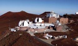
The GEODSS tracks deep-space objects such as high-orbit satellites from its three global sites in Socorro, N.M.; Maui, Hawaii; and the island of Diego Garcia in the Indian Ocean. The order brings the total cumulative face value of the contract to $818.6 million.
The GEODSS system tracks more than 2,5000 objects like geostationary communications satellites, which vary in altitude in space from 6,214 miles to nearly 28,000 miles above the Earth's surface.
GEODSS tracks space objects ranging from active satellite sensor payloads like weather monitoring satellites or Global Positioning System satellites, to space junk like rocket bodies from previous satellite launches or debris from past satellite breakups.
Each GEODSS site uses three one-meter telescopes with sensitive digital cameras to keep track of high-altitude space objects. These telescopes can see objects 10,000 times dimmer than the human eye can detect.
The GEODSS electro-optical telescopes take rapid electronic snapshots of satellites in the night sky, which show up on the operator’s console as tiny streaks. Computers then measure these streaks and compute the position of satellites in their orbits. Star images, which remain fixed, function as reference or calibration points for each of the three telescopes.
The GEODSS system has been an important piece of the space situational awareness mission since the early 1980s. For more information contact L3Harris Technologies online at www.l3harris.com, or the Air Force Space and Missile Systems Center at www.spaceforce.mil/About-Us/Fact-Sheets/Article/2197750/space-and-missile-systems-center.
