Airbus picks Teledyne Space to provide imaging sensors on European MetOp-SG-A1 Earth-observation satellites
Summary points:
- Airbus selects Teledyne imaging sensors — CCD314, CIS119, and CCD327-20 — for the first MetOp-SG-A1 next-generation weather and Earth-observation satellites.
- MetOp-SG-A1 launched from Kourou to provide high-resolution meteorological, climate, and atmospheric data, orbiting Earth 14 times daily.
- Six-satellite program will deliver Europe’s primary polar-orbit meteorological data for the next two decades in partnership with ESA, EUMETSAT, and NOAA.
OTTOBRUNN, Germany – Satellite designers at Airbus Defence and Space GmbH in Ottobrunn, Germany, needed detectors for three imaging sensors aboard the European MetOp-SG-A1 Earth-observation satellites. They found a solution from Teledyne Space Imaging in Chelmsford, England.
Airbus Defence and Space GmbH in Ottobrunn, Germany, chose the Teledyne CCD314, CIS119, and CCD327-20 imaging sensors for the MetOp-SG-A1 Earth-observation satellites launched on Wednesday from Europe's Spaceport in Kourou, French Guiana.
MetOp-SG-A1 is the first pair of next-generation satellites that will orbit the Earth together 14 times a day to observe any location on Earth. Three satellite pairs will launch over the next two decades.
Imaging and Earth observation
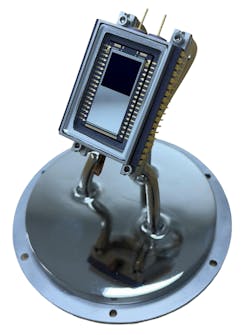
The Teledyne Space Imaging CCD314 sensor is a large-format frame transfer charge-coupled device imaging sensor designed for Earth observation and science missions.
The Teledyne Space Imaging CIS119 is a custom complementary metal oxide semiconductor (CMOS) imaging sensor developed for meteorological and climate observation from space. The Teledyne Space Imaging CCD327-20 is a sensor housed in the 3MI instrument on EUMETSAT's MetOp-SG-A1 satellite. The CCD327-20 is based on the Teledyne CCD47-20 sensor, and covers the visible-to-near-infrared wavelength bands from 400 to 920 nanometers. Teledyne Space Imaging also supplied detectors for three instruments on the MetOp-SG-A1 satellite.
The Metop-SG satellites are developed under a European Space Agency (ESA) contract by a European industrial consortium led by Airbus Defence and Space.
Tell me more about MetOp-SG-A1 Earth-observation satellites ...
- Meteorological Operational Satellite – Second Generation A1 (MetOp-SG-A1) is the first of six meteorological satellites developed by the European Space Agency and EUMETSAT to succeed the legacy MetOp program. The first pair launched last week for near-sun-synchronous polar orbit. The weather-forecasting spacecraft will be Europe's principal source of polar-orbit meteorological data for short-term and medium-range forecasts, as well as for monitoring atmospheric composition, climate trends, storm tracking, and emergency response.
The MetOp second-generation mission is part of the European Organization for the Exploitation of Meteorological Satellites' (EUMETSAT) Polar System, which is Europe's first contribution to the Joint Polar System shared with the U.S. National Oceanic and Atmospheric Administration (NOAA).
The Sentinel-5 satellite, which is part of the MetOp-SG-A1 Earth-observation satellite system, is a high-resolution imaging spectrometer that will monitor Earth's atmosphere globally. The spacecraft analyzes light reflected by the atmosphere across ultraviolet, visible, near-infrared, and shortwave infrared wavelengths to provide detailed measurements of atmospheric gases and aerosols.
For more information contact Teledyne Space Imaging online at www.teledyne-e2v.com/en-us, or Airbus Defence and Space at www.airbus.com/en/products-services/space.
About the Author
John Keller
Editor-in-Chief
John Keller is the Editor-in-Chief, Military & Aerospace Electronics Magazine--provides extensive coverage and analysis of enabling electronics and optoelectronic technologies in military, space and commercial aviation applications. John has been a member of the Military & Aerospace Electronics staff since 1989 and chief editor since 1995.
