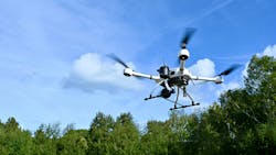
DLR demonstrates 5G drone system delivering live emergency images ahead of first responders
ROSTOCK, Germany - Every second counts for emergency services and rescue personnel in the event of a forest fire, traffic accident or natural disaster. Yet at the start of an operation, precise information about the situation on the ground is often scarce – especially in complex terrain or areas that are difficult to access. For this reason, Vodafone, Frequentis and the Rostock fire brigade – led by the German Aerospace Center (Deutsches Zentrum für Luft- und Raumfahrt; DLR) – have joined forces in the ADELE project to improve conditions for emergency responders. For the first time, they are now testing the deployment of automated drones immediately following an emergency call. Even before rescuers arrive, the drones can transmit high-resolution live images from the incident site directly to the emergency control center, DLR reports.
Continue reading original article.
The Military & Aerospace Electronics take:
26 Sept. 2025 -The demonstration highlighted several enabling technologies. The drone used 5G data transmission to stream real-time audiovisual data with end-to-end encryption, allowing both the control center and rescue teams to see the situation before first responders arrived. This high-speed connection ensures that decision-makers have immediate access to reliable imagery.
Another element is automated dispatch and flight planning. When an emergency call is received, control center software provides geocoordinates to an Automated Drone Dispatch System, which proposes a mission. Once approved, the drone autonomously plans its route and launches. The approach supports flights beyond visual line of sight, depending on regulatory approval.
The system also introduces a novel method of risk assessment through the "DroNet Hub." Instead of relying on static population data, the hub draws on anonymized mobile-device information to estimate how many people are present in the area at a given time. This live risk analysis improves flight authorization processes and helps ensure safe operations during emergencies.
Related: FAA aims to evaluate utilizing small unmanned aircraft for facility maintenance
Related: Urban Aeronautics announces pre-orders for its EMS CityHawk
Related: EHang launches high rise firefighting autonomous aerial vehicle
Jamie Whitney, Senior Editor
Military + Aerospace Electronics
