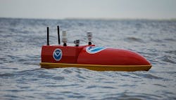
Not just for the Navy: unmanned surface vessels (USVs) in wide use for surveillance at NOAA
Future Navy unmanned marine vessels as motherships to launch and recover UUVs, USVs, and even unmanned aerial vehicles (UAVs). Navy applications capture the imagination so deeply that sometimes we forget about other users of these unmanned waterborne technologies.
Take the U.S. National Oceanic and Atmospheric Administration (NOAA), for example. NOAA's mission ranges from tracking changes in the weather, charting shifting sandbars along treacherous coastlines, to monitoring the health and well-being of marine wildlife sanctuaries.
The agency -- a bureau of the U.S. Commerce Department -- faces the daunting task of observing atmospheric and oceanic phenomena at far-flung locations all over the world, with far more miles to cover than the agency has personnel.
Related: NOAA's small unmanned surface vessels (USVs) help map the ocean's shallow floors
In other words, NOAA is a perfect place for unmanned vehicles, which excel at the dull, boring, dangerous, and dirty jobs that human beings wouldn't want to do, even if they had the time and money to do them.
Just this week came a story from Popular Science about how NOAA is using small robot boats -- or "roboats" as the magazine terms them -- to take measurements of quickly changing coastal features to help keep nautical charts up to date.
Mariners of every stripe, from commercial tanker captains to weekend pleasure boat sailors, rely on NOAA nautical charts to help keep them out of trouble. Without accurate charts, boats can run aground, or worse. It's essential to have frequently updated measurements to keep mariners out of harm's way.
Then there's the Emergency Integrated Lifesaving Lanyard (EMILY) Hurricane Tracker unmanned surface vessel, developed with NOAA funding by Hydronalix in Green Valley, Ariz. The EMILY Hurricane Tracker is five and a half feet long USV balanced to operate in heavy weather for as long as five to ten days at speeds to 7 knots.
Related: Navy chooses AAI Textron to provide mine-hunting unmanned boat for Littoral Combat Ship
This unmanned vessel, a new tool for hurricane research, has a satellite link, camera, reciprocating internal combustion engine, and a variety of sensors. EMILY is collecting sea-level data for NOAA.
NOAA also is working with Liquid Robotics Inc. in Sunnyvale, Calif., on a project to use the company's Wave Glider long-endurance unmanned surface vessel to keep tabs on shipping in marine protection areas such as the Channel Islands National Marine Sanctuary off the California coast.
NOAA officials are working with Liquid Robotics to evaluate the Wave Glider's ability to approach and discreetly image vessels and onboard activity.
NOAA also is working with Ocean Aero Inc. in San Diego to use the company's Unmanned Underwater Surface Vessel (UUSV) for a variety of long-endurance surveillance applications. The UUSV is a rugged surface and sub-surface vessel powered by wind and solar. It can spend several months at sea and can be deployed from land, sea or air.
Related: Navy to develop unmanned surface vessels as its newest generation of minesweepers
NOAA experts can configure the UUSV with a wide variety of sensor and observational systems to provide ocean-area surveillance and reconnaissance.
Unmanned submersibles also are helping NOAA researchers document and survey old shipwrecks from World War II off the coast of North Carolina. UUVs have helped researchers search for unknown shipwrecks in an area known as the Graveyard of the Atlantic.
In other projects NOAA experts are using sea gliders -- efficient UUVs that dive deeply to gather information from many layers of the ocean and the resurface to upload gathered data over radio links.
It just goes to show you that unmanned marine vehicles aren't just for the Navy. In fact, these types of unmanned vehicles are opening up new research vistas to learn more about the world's oceans for science, commercial, and military applications.
