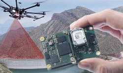
Inertial navigation for unmanned aerial vehicle (UAV) surveillance and surveying introduced by SBG
CHICAGO – SBG Systems in Carrières-sur-Seine, France, is introducing the Quanta UAV Series line of inertial navigation systems (INS) for unmanned aerial vehicle (UAV)-based surveying and surveillance applications.
SBG is introducing the embedded navigation and guidance system this week at the Association for Unmanned Vehicles Systems International (AUVSI) XPONENTIAL conference and trade show in Chicago.
SBG Systems has designed a small, lightweight, and low-power inertial navigation system offered on two levels of accuracy to enable UAV surveyors to save autonomy for additional survey lines.
The company developed Quanta UAV and Quanta UAV Extra to add compact light detection and ranging (LiDAR) to high-end beyond-visual-line-of-sight (BVLOS) mapping solutions.
These products provide precise orientation and centimeter level position data in real-time and post-processing for surveillance and surveying. This direct geo-referencing solution eliminates the need of ground control points and can reduce the need of overlapping.
SBG's post-processing software gives access to offline RTK corrections from more than 7,000 base stations located in 164 countries. Processing inertial data and raw GNSS observables in forward and backward directions can improve trajectory and orientation.
This advanced software also computes a base station position to move projects to the centimeter accuracy.
Quanta UAV is the result of SBG's expertise in miniaturized technology for drone navigation and high-end sensors for mobile mapping. Designed as a geo-referencing solution, it also can serve as a high-end navigation solution to feed the UAV autopilot.
Related: Sensor payloads for unmanned vehicles
In-house inertial measurement units, advanced calibration techniques, and algorithms ensure a consistent behavior in all weather conditions, and give precise position even if the UAV gets close to buildings, electrical lines, or trees.
SBG Systems embeds a web interface for configuration with a 3D view showing all parameters. The calibration tool automatically aligns the lever arm between the two antennas and the sensor, and re-estimates it in flight for more precision.
For more information contact SBG Systems online at www.sbg-systems.com.
Ready to make a purchase? Search the Military & Aerospace Electronics Buyer's Guide for companies, new products, press releases, and videos
