Synthetic vision: road to credit

Aug. 4, 2010
Synthetic vision, a computer-generated depiction of the terrain and obstacles from the pilot's perspective, is coming into wider use in many aircraft -- from high-end business jets to workhorse helicopters. Although the technology has not yet received credit from the Federal Aviation Administration (FAA), it clearly increases situational awareness and reduces workload in the cockpit. Regardless of the weather or time of day, it is always visual flight rules (VFR) at noon on the synthetic vision display.
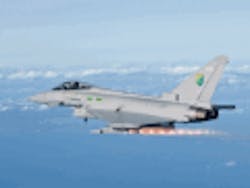
By Charlotte Adams Synthetic vision, a computer-generated depiction of the terrain and obstacles from the pilot's perspective, is coming into wider use in many aircraft -- from high-end business jets to workhorse helicopters. Although the technology has not yet received credit from the Federal Aviation Administration (FAA), it clearly increases situational awareness and reduces workload in the cockpit. Regardless of the weather or time of day, it is always visual flight rules (VFR) at noon on the synthetic vision display. Often presented on the primary flight display (PFD), the depiction is essentially derived from terrain/obstacle databases, attitude information, and the navigation solution. Today's systems are meant for situational awareness, not navigation. Synthetic vision heightens pilot awareness in night operations, instrument conditions, mountainous terrain, instrument approaches, and unusual attitudes and increases awareness of obstacles, approach path deviations and of the runway's location when one comes out of the clouds. Honeywell Aerospace in Phoenix unveiled the first high-end, business-jet synthetic vision system, dubbed SmartView, in 2008 on the Gulfstream G450 as an option for its Primus Epic integrated avionics suite. Since then SmartView has become available for the G150, G500, and G550, and today about 150 Gulfstreams are equipped with synthetic vision, says Chad Cudiff, vice president of crew interface products at Honeywell. SmartView also will be an option on Dassault's EASy II upgrade and a standard feature on the new Gulfstream G650. The Pro Line Fusion avionics suite from Rockwell Collins in Cedar Rapids, Iowa, -- not yet certified on an aircraft -- is initially targeted at the Bombardier Global family, starting with the Global Express, as part of the Global Vision cockpit upgrade, and the Gulfstream G250. Both approvals are expected next year. Honeywell and Rockwell Collins The latest version of the Honeywell system, "certification Foxtrot," was approved last year for Gulfstream's PlaneView cockpit. The new features will flow over to the EASy II upgrade, as well, although they may look slightly different on Dassault's synthetic vision implementation. The synthetic depiction, which uses Honeywell's enhanced ground proximity warning system (EGPWS) database, is overlaid on the PFD. SmartView also features conformal, color-coded terrain, conformal grid lines to give the pilot a sense of motion and perspective, and range rings for indicating distance to features, with runway detailing such as the runway number, centerline, and pavement color, and texture. Honeywell also extends the runway centerline as a dotted line of "bread crumbs" from 2 to 10 nautical miles out as an aid to situational awareness. The PFD also presents a horizontal situation indicator (HIS) in the center of the lower third of the display, with an overhead view of the terrain, aircraft heading, and range ring. Traffic targets appear on the HSI as well as the multi-function display (MFD). Rockwell Collins takes a somewhat different approach. It will be the first in commercial aerospace to certify and field head-up synthetic vision, says Adam Evanschwartz, product marketing manager at Rockwell Collins. Synthetic vision can be displayed head-up and head-down -- on the PFD and, optionally, on the MFD. The pilot will be able to select infrared-based enhanced vision or synthetic vision on the head-up display (HUD) via a control on the yoke. The synthetic vision and enhanced vision pictures, however, will not be "blended," he notes. Synthetic vision will be standard in the Global Vision cockpit and optional on the G250.
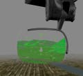
The resolution of the underlying database is better than 6 arc seconds worldwide although the whole visual image need not be of a uniform resolution, Evanschwartz explains. For terrain close to the aircraft, however, Pro Line Fusion displays support the higher resolution. Terrain is also color-coded. Although the infrared image will not be correlated with the synthetic picture and the flight guidance symbology on the PFD, the display can be divided vertically and the right half subdivided into two quarters which could present the infrared view, XM weather, overhead view of terrain, security camera view of landing gear, or other information. In this windowed format, the left half of the pilot's PFD would continue to display flight guidance and synthetic vision. Rockwell Collins continues to study the combining of enhanced vision and synthetic vision. "What was driving and still drives a lot of research is the need for pilots using synthetic vision to have confidence in that scene, verifying [its] accuracy and validity," Evanschwartz says. The synthetic vision on the HUD comes from the same computer and database that serve the head-down display. The new liquid crystal display (LCD) HUD uses LED backlighting, allowing a wider range of brightness and increased contrast control, Evanschwartz says. "You can differentiate clearly the primary flight symbology from the synthetic or enhanced [picture]."Although the new HGS-6000 HUD is monochromatic, it normally shows six to eight shades of green and presents four levels of green in bright sunlight, says John Wilson, Rockwell Collins' principal marketing manager. The HGS-6000 is also 20 percent brighter than the earlier-generation HGS-5000 display, he said. In addition the LED backlighting requires less space than the prior silicon projector technology. Rockwell Collins' synthetic vision presents airports as half domes. On approach and arrival the dome fades away and the runway complex appears with the landing runway highlighted in a unique color. The runway centerline symbol extends 2.25 nautical miles out at a 0.5 degree incline, resembling a row of lowercase t's, known in the company as "telephone poles." Credit ratings Now that synthetic vision has a strong foothold in the market, avionics manufacturers and operators are seeking operational credit. Some people are looking at synthetic vision as a "bridge" to enhanced vision on certain segments of instrument approaches, Evanschwartz says. Synthetic vision could get you to the point where you can see the runway with enhanced vision. FAA officials already have granted credit for aircraft equipped with enhanced flight vision systems (EFVS) -- certified HUDs displaying enhanced vision as well as flight guidance -- to go below minimums on Cat I ILS and straight-in non-precision approaches. If the pilot can acquire the runway environment at the decision height (DH) or minimum descent altitude (MDA) with EFVS, he can go below the DH or MDA, to 100 feet height above touchdown zone, before acquiring the runway with the naked eye. The real-time sensor allows the pilot to pick up visual references and the HUD allows a natural transition from instrument to visual flying. Basically, all the operator needs are the special HUD and EFVS training. At least one FAA official regards the combination of synthetic vision and EV, along with flight guidance, on a HUD as promising. This "would certainly go a long way [toward] operational credit," says Les Smith, manager of the Flight Technologies and Procedures Division in the FAA's Flight Standards Service. He pointed to the FAA's Order 8400.13, for example, which has been used to allow operational credit or reducing visibility minimums for instrument approach procedures. "So, depending on the accuracy of the synthetic visions, along with the navigation system they would be using, we're moving towards…[using] that order …to reduce the visibility minimum for the instrument approach procedure," Smith says. RTCA's Special Committee (SC-213) is currently working on visual augmentation technologies. The ultimate goal is "to have the technology that would allow the pilot to fly in any weather conditions down the runway for a landing without looking outside," Smith continues. Airlines approved for Cat IIIc ILS operations can do that today, but business jet operators want approach credit without the expense of maintaining Cat III-certified crews. Cat III ILS solves the positioning problem with FAA standards and criteria on ILS technology. It solves the data problem by making sure there are no obstacles in the approach path. Ultimately, however, the goal is "aircraft-centric operations," Smith says, where everything you need to fly in all weather conditions and be very cognizant of all the terrain and obstacles around the aircraft is in the aircraft. The challenges of synthetic vision are its dependence on two main inputs, explains Bruce Decleene, manager of the Avionics Systems Branch in the Aircraft Certification Service. These are the ability of the positioning system to know where the airplane is and of the underlying database to know all the surrounding environment -- including both terrain and obstacles -- with accuracy and integrity. To move from situational awareness to operational credit the requirements for integrity and accuracy will get more stringent. There are two ways to solve the problem, Decleene says. The first is to build a more reliable system to meet the more demanding requirements. The second is to have redundancy in the system, such as an independent method to monitor it. The FAA is "open to either architecture," he continues. RTCA has kicked around the idea of an independent monitor, he adds. They are considering the use of GPS-based synthetic vision together with ILS, a completely independent system. The idea is that those two systems, used together, would automatically monitor each other in the approach phase. The ILS signal would be used to monitor the GPS signal for position and eliminate the GPS time-to-warn problem if there is a satellite failure, says Tim Etherington, co-chair of SC-213. Similarly, the GPS signal would automatically be monitored against the ILS precision navigation signal. Such a scenario could be a "baby step" toward synthetic vision for credit. At a meeting last month the RTCA committee made progress on work toward EFVS for landing with no DH and a 1000 RVR visibility requirement, Etherington says. He expects this document to be published by December. The synthetic visions-for-credit work is going more slowly. The committee is trying to use FAA Order 8400.13 for approval, and the first synthetic vision-for-credit operation may be 150-foot DH, instead of the target 100 foot, he said. The approval would fit under a "special authorization Cat I," he adds.

Voice your opinion!

To join the conversation, and become an exclusive member of Military Aerospace, create an account today!