Helicopter terrain avoidance systems (HTAWS) to be required by FAA for air ambulances

Nov. 4, 2010
WASHINGTON, 4 Nov. 2010. The Federal Aviation Administration (FAA) issued a notice of proposed rulemaking (NPRM) that would require helicopter air ambulance operators to make significant changes in equipage, infrastructure, and procedures. While operators avoided mandates for autopilots and night vision goggles (NVGs), as the National Transportation Safety Board had wished, they will have to equip with approved terrain avoidance systems (TAWS) if the NPRM goes through as written.
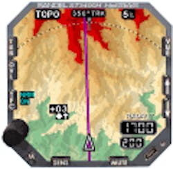
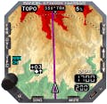
By Charlotte AdamsWASHINGTON, 4 Nov. 2010. The Federal Aviation Administration (FAA) issued a notice of proposed rulemaking (NPRM) that would require helicopter air ambulance operators to make significant changes in equipage, infrastructure, and procedures. While operators avoided mandates for autopilots and night vision goggles (NVGs), as the National Transportation Safety Board had wished, they will have to equip with approved terrain avoidance systems (TAWS) if the NPRM goes through as written.Among the other requirements proposed for the helicopter emergency medical services (HEMS) industry are operations control centers if certificate holders fly 10 or more helicopter air ambulances, the conducting of all flights with medical personnel aboard under Part 135 flight crew rest rules, preflight risk analysis and instrument ratings for pilots in command. Comments are due by Jan. 10, 2011.The justification is safety. Although the FAA initially addressed HEMS safety concerns through voluntary measures, the agency has now switched gears. "We've been very, very concerned with the accident rate in the HEMS arena," says John Allen, FAA's director of Flight Standards. The NPRM points to the increase in fatal helicopter air ambulance accidents from 2002 to 2008. Sixteen crew members have died in accidents so far this year, which is more than half of the 28 crew members and patients killed in 2008, the industry's worst year.The NPRM notes two accidents that helicopter terrain awareness and warning systems (HTAWS) could have helped prevent. In the first case the pilot was flying low over a lake and lacked visual clues as to altitude. In the second the pilot was maneuvering in low-visibility conditions. The proposed rule argues that HTAWS is particularly relevant for air ambulance operators since the equipment can help pilots to maintain situational awareness of terrain and obstacles and therefore help prevent accidents caused by controlled flight into terrain, inadvertent IMC and night operations. HEMS pilots often fly at night, encounter inadvertent IMC and land in unimproved areas. Helicopters cannot simply adopt fixed-wing TAWS systems because these systems would cause too many distracting nuisance warnings. But the newer HTAWS technology takes helicopter speed and altitude characteristics into consideration and assesses the aircraft's position over a smaller area of terrain. The NPRM explains that HTAWS uses position sources to determine the ship's horizontal and vertical position and compare it to the surrounding terrain. The equipment "derives a helicopter's ground speed, position, and altitude from a …GPS [system] and a preprogrammed algorithm database.”"The FAA estimates that there are 989 air ambulance helicopters, about 200 of which are already equipped with HTAWS technology. The agency calculates that the remaining 789 HEMS choppers would incur a per unit equipage cost of about $35,000 (including installation), for a total of around $27.6 million, excluding the cost of aircraft downtime. The total cost to the HEMS industry of the various proposals ranges from $62 million to $1.5 billion over a 10-year period.HTAWS systems have been available since 2001 but only received the FAA seal of approval -- technical standard order (TSO) C-194 -- in December 2008. The HEMS industry has seen this requirement coming for a long time, and many of the larger operators have begun to equip. At least one HEMS early adopter, however, equipped its large fleet with terrain warning systems which do not meet the TSO. Air ambulance operators have three years from the effective date of the final rule to install approved terrain systems.The HTAWS TSO C-194 is more general than the earlier TSO C-151b for fixed-wing TAWS systems: the HTAWS document does not divide systems into Classes A and B, for example, although manufacturers continue to discuss HTAWS products in these terms. (Class A includes a wider range of warnings than does Class B.) The key HTAWS document, RTCA's DO-309, is also rather general, envisioning a wide range of implementations and avoiding hierarchy. The market reflects this performance range. The HTAWS document calls for the ability to show terrain and obstacle data in color on a cockpit display and describes the typical components -- horizontal and vertical position inputs and terrain and obstacle databases. It also provides alert prioritization, an alert envelope and correlates warning alerts with descent rates and height above terrain. HTAWS marketMultiple suppliers meet the TSO, including Honeywell, Sandel Avionics, Garmin, and Cobham. Cobham's system, however, is part of an integrated electronic flight instrument system (EFIS). Honeywell was the first to certify its products, the MK XXI and MK XXII HTAWS, under C-194 in August 2009. About 1,200 MK XXIIs and more than 400 MK XXIs -- both of which were first introduced some years before the HTAWS TSO -- have been installed. Honeywell boasts more than 1 million HTAWS flight hours since 2001, when it first brought helicopter EGPWS technology to the market, says Dereck Clark, Honeywell's marketing and product manager for EGPWS (enhanced ground proximity warning system), the company’s brand name for its TAWS and HTAWS products. Honeywell controls updates through a centralized process. Requests to add new obstacles are considered by the company's database team and updates are made about four times a year. Honeywell also emphasizes its core EGPWS terrain and obstacle database with more than 800 million flight hours.
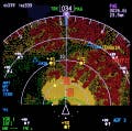
While supplying whole cockpits to the business aviation market, Honeywell emphasizes the interoperability of its HTAWS products with third-party displays. The more sophisticated MK XXII sells for about $55,000 and the MK XXI for about $16,000, excluding the cost of installation. MK XXII and MK XXI features correspond respectively to Class A and Class B characteristics, as defined by TSO C-151b, the earlier TSO.SandelSandel announced TSO supplemental type certificate (STC) approval of its ST3400H HeliTAWS product in August 2010. The basic system is priced at $19,000, according to Jerry Henry, director of sales, marketing ,and technical services at Sandel. Internal on-demand filtering for NVGs is an optional feature costing about $3,500, but all buyers so far have chosen to adopt it, he says. Among Sandel's announced customers are MSP Aero, which installs equipment for HEMS operators, and Metro Aviation, a HEMS operator.Sandel, which also offers TAWS to the fixed-wing market, designed HeliTAWS specifically for the retrofit market, Henry says. "We made it so that it could replace virtually any radar altimeter indicator currently in production." Customers would use the Sandel system to display radar altimeter information, eliminating other instrument panel modifications. This reduces cost, conserves cockpit real estate and ensures that the HTAWS information is presented in the pilot's primary field of view, he says. HeliTAWS is "completely self-contained in one instrument," Henry says. The 3ATI package has a viewing area of about 3 inches by 3 inches. Sandel's terrain database provides 3-arc-second terrain data, he adds. The company buys terrain and obstacle data from Jeppesen, formats the data to its own specifications and resells subscriptions. Sandel is also developing a partitioned "user database" that will allow customers to input unique obstacles or off-airport landing areas. Since the user database will be partitioned from the terrain and obstacle databases, customers will be able to update the user database without affecting the others.The relatively new design takes advantage of near-ubiquitous GPS equipage, foregoing internal GPS cards. Sandel's market study found that approximately 99.9 percent of helicopters were already equipped with GPS.This design decision lowers the cost and simplifies the installation. HeliTAWS displays not only terrain and obstacles -- with all six Class A ground proximity warning system alert/warning modes -- but also traffic alerts, flight plans, and radar altitude with aural descent AGL callouts. But its most unique aspect is "nuisance-free alerting," Henry says.Sandel is taking a data-driven approach to alerting for power lines, a challenge to obstacle avoidance systems. The company's hardware and software are "designed to accommodate power line data," Henry says. Sandel also is "actively involved with the most significant power companies." Active power line sensors are available but are very heavy and expensive, he says. GarminGarmin announced the STC certification of its HTAWS software upgrade to the GNS 430W and 530W navigators in September 2010. The HTAWS meet the requirements of TSO C-194, the company says. The price for the field upgrade is about $10,000 per unit, and the 430W and 530W are priced at $11,295 and $16,495, respectively. The software is also available as an option on new systems. The communication/navigation products have built-in GPS. The screens of the GNS 430W and 530W are 4- and 5-inches diagonal, respectively, with rectangular- and square-shaped viewing areas. The HTAWS capabilities of both products are essentially similar. If the pilot is viewing information other than HTAWS when a terrain/obstacle warning becomes necessary, the system will present popup messages that occupy most of the screen of the 430W and the center of the 530W display. The pilot pushes "CLR" to return to the previous page or "ENT" to access the HTAWS page. Visual and aural alerts are issued simultaneously. Garmin's HTAWS provide forward looking terrain avoidance and voice callouts in all HTAWS modes. Pilots can select multiple callouts, Garmin says, in 100-foot increments, from 500 to 100 feet AGL. There is also a "reduced protection" mode to minimize alerting while still providing terrain and obstacle protection, according to the company.

Voice your opinion!

To join the conversation, and become an exclusive member of Military Aerospace, create an account today!