Drones, better model help Navy improve hurricane intensity forecasts
Reproduced with permission from The Txchnologist.
By Rebecca Ruiz
Forget Moby Dick’s white whale – a tropical cyclone is by far the most difficult ocean beast to track. This rotating system of clouds and thunderstorms, most commonly known to North Americans as a hurricane once it reaches a certain size and speed, is typically several hundred miles wide with winds as fast as 155 miles per hour.
These vast storms are essentially a physics puzzle, in which the interaction of moisture, wind, air, heat and other elements can trick even the most knowledgeable scientists trying to forecast both the path and intensity of a hurricane. In the last decade, weather models have gotten much better at predicting path and landfall, but they have been less skillful when trying to estimate pressure and maximum wind speeds.
So when the U.S. Navy’s Fleet Numerical Meteorology and Oceanography Center recently launched a new hurricane prediction model capable of tracking a storm’s intensity, it was no small feat. Known as COAMPS-TC (Coupled Ocean/Atmosphere Mesoscale Prediction System-Tropical Cyclone), the model can accurately forecast wind strength one to five days out. This is essential information for fleets and installations that might need to evacuate or protect their facilities—under- or overestimating the strength of a storm can be a costly mistake.
A flawed model gets upgraded
Dr. Ronald Ferek, the Office of Naval Research program officer responsible for COAMPS-TC, tells Txchnologist that previous models relied on incorrect assumptions about how surface friction, heat moisture and momentum exchange of ocean water behave at high wind speeds.
Researchers once thought that the friction continued to increase in those conditions, creating a drag effect that would slow down a cyclone. But a series of experiments measuring surface friction showed that assumption to be wrong. For years, in the absence of such measurements, the prediction models had been trying to overcome friction that was less than assumed. That new formula is a key reason why COAMPS-TC has succeeded where previous ones failed.
The improved physics algorithms work in conjunction with its data analysis to produce the most accurate forecast possible. COAMPS-TC processes data in real time, and it is fed by millions of observations logged by satellites, remote-sensing stations, and weather balloons and stations.
Still, when it comes to measuring a hurricane, there are limits to the available data. Hurricane-hunting aircraft can only fly up to 30,000 feet, but the storms reach up to 65,000 feet into the atmosphere. Satellites can capture images of a hurricane at this height, but often don’t deliver information detailed enough to tell scientists what’s happening at that altitude. That’s where a drone comes in handy.
Remote-controlled helpers
Last summer, NASA’s Global Hawk drones flew over two storms at 60,000 feet and dropped parachute-equipped devices that collected temperature, humidity and wind measurements. Ferek says that when this information was integrated into the model, intensity forecasts improved by about 25 to 40 percent. “Only by flying over with Global Hawks and getting data from 65,000 feet to the surface,” says Ferek, “did we begin to understand these missing physics.”
Despite the accuracy seen in three years of testing COAMPS-TC, the model occasionally “busts” because scientists still don’t fully understand how a hurricane behaves between the sea and sky. A warm ocean eddy or high-altitude phenomenon might throw the model off. “It’s never the same thing every time,” Ferek says.
Researchers want to learn even more about a hurricane’s upper-level mechanics, particularly how the jet stream interacts with a storm, which the models don’t yet capture well. The results of the Global Hawk experiment were tantalizing, but it’s not yet policy to send a drone into every hurricane. It’s also possible that other data-collection tools, like satellites, could be improved to log the important missing data.
Ferek believes predictions will rapidly improve as the model better analyzes hurricanes at high altitude. Within five years he expects to see models that are more skilled at estimating a storm’s intensity. In the meantime, he and his colleagues are enjoying the launch of COAMPS-TC.
“We’re sort of proud of it,” Ferek says, “because I think we solved a fundamental problem with sea-surface physics and that opened up a whole new line of research.”
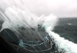
Top Image: The freedom class littoral combat ship USS Fort Worth transits through heavy seas in the Atlantic Ocean during a storm on Aug. 18, 2012. Courtesy U.S. Navy.
Bottom Image: A graph from the Navy showing improved wind speed prediction accuracy using the new COAMPS-TC cyclone intensity forecasting model. Courtesy U.S. Navy.
Rebecca Ruiz covers military, veteran and home front issues. She was formerly a reporter for NBC News and a staff writer at Forbes. Follow her on Twitter at @rebecca_ruiz.

