Enhancing pilot situational awareness for increased safety

Modern helicopter avionics technologies enhance situational awareness to increase safety and reduce common aviation accidents.
By Courtney E. Howard
Aviation accidents can have far-reaching effects and often unforeseen consequences. Rather than recoiling in reaction to helicopter-related fatalities, the rotorcraft community has banded together and taken a proactive approach—advancing cockpit avionics technologies to aid in reducing unfortunate aviation incidents, assisting pilots, and bolstering safety.
Industry & government partner
Government regulators, aircraft and avionics manufacturers, and helicopter operators came to a consensus in 2005 that the rate of worldwide helicopter accidents was unacceptably high. By the end of the year, leaders from the American Helicopter Society (AHS), Helicopter Association International (HAI), manufacturers and other interested organizations, and the U.S. Federal Aviation Administration (FAA) had joined together to establish the International Helicopter Safety Team (IHST). IHST is a global group of industry and government professionals working in concert toward an aggressive goal: to reduce the worldwide helicopter accident rate by 80 percent in 10 years (by 2016).
The IHST developed and implemented a “data-driven, benefit-focused safety program designed to continuously reduce the risk of helicopter accidents,” describes a representative. “The IHST chartered a Joint Helicopter Safety Analysis Team (JHSAT) to develop data-driven safety recommendations in pursuit of the goal to reduce the accident rate and fatality risk.” The JHSAT includes key stakeholders in helicopter design, manufacture, operation, training, and regulation. (Read more on IHST in “Spotlight on helicopter safety,” an interview with Fred Brisbois, Co-chair, U.S. Safety Implementation Team, IHST Executive Committee.)
IHST professionals in the U.S., Canada, and Europe analyzed more than 800 helicopter accidents and issued four intervention recommendations: implement safety management systems (SMS); improve training (including simulator/flight training device utilization, and aeronautical decision-making); improve maintenance practices; and leverage new technologies though new systems and equipment. Avionics technology plays a major role throughout these safety recommendations.
“When choosing avionics, make sure you look at the capabilities you will add in the future, and not what it can do for you right now. You may end up replacing all your avionics later, for something you could have installed the first time around.”
-- Brett Harlow, military/government aviation business development manager at Garmin International in Olathe, Kan.
Accident statistics
“The International Air Transport Association (IATA) named 2012 the safest year in recent aviation history for fixed-wing commercial aviation; however, helicopter safety is still a paramount concern,” admits Trish Ververs, engineer fellow with Honeywell’s Advanced Technology Group in Baltimore, Md. Her concerns are well founded.
In 2012, HeliHub (http://helihub.com/) recorded a total of 133 fatal helicopter accidents, involving the loss of 420 lives. Military helicopters accounted for 50 such events and 246 lives (4.9 per accident), while civil helicopters were involved on 83 occasions with 174 lives lost (2.1 per accident).
Many factors likely contribute to a higher incidence of accidents and fatalities compared to fixed-wing aircraft. Helicopter missions often operate close to challenging terrain and involve off-airport takeoffs and landings, notes a spokesperson at Sandel Avionics in Vista, Calif. “Helicopters routinely operate below 500 feet above ground level (AGL); obstacles and especially power lines are a threat to helicopter operations throughout the mission, not just at takeoff and landing.”
“Design avionics from a human-centered systems perspective, so that the information provided is
easy to use, easy to interpret, and supports the pilot in all phases of flight.”
-- Trish Ververs, engineer fellow with Honeywell’s Advanced Technology Group in Baltimore, Md.
Curtailing causes
Controlled flight into terrain (CFIT) and inadvertent instrument meteorological conditions (IMC) are associated with a great many helicopter accidents and, therefore, the focus of many safety discussions. Both CFIT and inadvertent IMC involve diminishing visibility and, in turn, a loss of situational awareness—or knowledge of one’s surroundings.
“CFIT has been a major aviation safety issue for several decades,” Robert O. Phillips of the U.S. Department of Transportation (DOT) Federal Aviation Administration (FAA) admitted in his report, “Investigation of Controlled Flight into Terrain: Descriptions of Flight Paths for Selected Controlled Flight into Terrain (CFIT) Aircraft Accidents, 1985-1997.”
“A CFIT accident occurs when an airworthy aircraft, experiencing no contributory systems or equipment problems, under the control of a certificated, fully qualified flight crew no suffering from any impairment, is flown into terrain (or water or obstacle) with no demonstrated prior awareness of the impending collision on the part of the crew. Or, if the flight crew was aware of the impending collision, they were unable to prevent it,” Phillips wrote, referencing David Spiller of the Volpe National Transportation Systems Center in Cambridge, Mass. (Spiller wrote: “Investigation of CFIT Accidents Involving Multi-Engine, Fixed-Wing Aircraft Operating under Part 135 and the Potential Application of a Ground Proximity Warning System” in 1989.)
“Most CFIT accidents have in common a chain of events leading to what human factors experts term ‘lack of situational awareness’ on the part of the flight crew,” Phillips affirms. “Conditions of limited visibility (due to darkness or weather or both) are typically a major contributing factor.”
A majority of such accidents involve high-speed impacts and, as a result, typically have disastrous consequences. In fact, statistics from the U.S. National Transportation Safety Board (NTSB) in Washington indicate that 60 percent of all CFIT accidents are fatal. For this and other reasons, CFIT accidents “continue to be a primary cause of fatalities and airframe losses in aviation,” explained Major Michael L. Moroze and Dr. Michael P. Snow, Air Force Research Laboratory (AFRL), Wright-Patterson Air Force Base, Dayton, Ohio, in their paper, “Causes and Remedies of Controlled Flight into Terrain in Military and Civil Aviation.”
“Over 50 percent of CFIT mishaps have situational awareness components listed as contributing factors,” Moroze and Snow wrote. “Several authors suggest that one of the most common attributes of CFIT accidents is pilot or crew lack of situation awareness. Other authors investigating this issue more specifically identify this behavior as a lack of terrain situation awareness or terrain awareness. In any case, it is the overall lack of the crew’s understanding of where they are and where they are going in three-dimensional (3D) space that enable CFIT to occur.”
“CFIT accident prevention has been the focus of considerable effort over the past 30 years on the part of government and industry,” Phillips described. “Preventing CFIT is, unfortunately, not an issue to be addressed solely by pilot training and experience.” Similarly, Moroze and Snow concluded in their 1999 paper that “systems are needed to improve flight crew situation awareness, especially terrain awareness.”
Tapping technology
CFIT remains the leading cause of aviation accidents worldwide, according to a representative at FlightSafety International in Flushing, N.Y. Yet, new developments in aircraft technology can increase a pilot's awareness of terrain.
Sandel Avionics officials agree, noting: “CFIT is a real and growing threat to helicopters. As the accident rate rises, private and public entities must find a solution to address the issue in an efficient and cost-effective way.”
Avionics technologies play a key role in reducing CFIT and inadvertent Instrument Meteorological Conditions (IMC). Technology firms are increasingly providing affordable, flexible, commercial off-the-shelf (COTS) technology that designed to deliver enhanced situational awareness in a number of ways, such as: streamlining cockpit avionics interfaces, reducing pilot workload, providing 3D synthetic views of obstacles, and helping flight crews recognize and avoid hazards to prevent accidents.
Operator experience
“A pilot can easily be task saturated and over stimulated by too many items in the cockpit,” recognizes Brett Harlow, military/government aviation business development manager at Garmin International in Olathe, Kan. “We have shown improvement in pilot interface by making it a lot easier to learn. And by condensing it into one to two simple screens, like Garmin has done, you also minimize the heads down time and keep them looking outside longer.”
Garmin officials have been working closely with the Defense Safety Oversight Council (DSOC), which provides governance on U.S. Department of Defense (DOD)-wide efforts to reduce preventable mishaps. Garmin’s objective is to add a level of safety not seen before in the military environment, Harlow says. Garmin’s COTS GNS/GTN navigators are designed to simplify installation and minimize down time, for example. “By adding a helicopter terrain awareness and warning system (HTAWS), in-flight weather, traffic, back-up radios, and communications, we not only improve safety of flight, but make the pilot’s and crew’s life a lot easier.”
The Garmin GTN 750/650 features a helicopter-specific obstacle database with nearly 30,000 low-altitude obstacles, as well as a navigation database with heliports and high-resolution terrain. “For added safety, optional HTAWS provides five-color shading to show nearby terrain in proximity to your helicopter, and provides voice callouts when descending below 500 feet,” Harlow describes. The GTN 750/650 is available with optional enhancements tailored to the demands of helicopter missions, and is optionally compatible with night vision imaging systems (NVIS) for use with a wide range of optics.
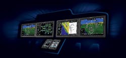
“What’s even better is when you pair the GTN series with a G500H,” Harlow adds. “Dual 6.5-inch LCD screens, mounted side-by-side in a single bezel, put primary flight display (PFD) and multifunction display (MFD) capabilities right in front of you for easy scanning and interpretation. The PFD screen shows attitude, airspeed, altitude, climb rate, and course/heading information, while the left-side MFD provides detailed moving-map graphics with the helicopter’s current position in relation to ground features, chart data, navaids, and flight plan routings.”
Synthetic vision is another safety benefit, “adding 3D obstacles, terrain, and traffic right in front of the pilot,” Harlow explains. “With technology advancing quickly, it’s key to exploit those advances and use them for the right reasons.”
Synthetic vision
Low visibility is a leading cause of helicopter accidents, observes Ververs at Honeywell. “The IHST reports that loss of pilot control accounts for one out of every five fatal helicopter accidents, and visibility issues are a close second. This has shown that while helicopter flight is ultimately safe, there need to be improvements to help it reach the level of fixed-wing safety.”
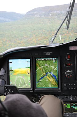
Honeywell’s Enhanced Ground Proximity Warning System (EGPWS) uses inputs—position, attitude, air speed, and glideslope, along with internal terrain, obstacles, and airport databases—to predict a potential conflict between the aircraft's flight path and terrain or an obstacle that the pilot might not see, such as radio towers or buildings. “As a result of EGPWS, the risk of controlled flight into terrain is now 50 times less in Western Europe and North America than it was in 1991, making this one of the biggest success stories in the history of aviation,” Ververs says. “Since the introduction of EGPWS in 1996, Honeywell has received reports of more than 30 incidents where the EGPWS gave an alert and provided pilots with timely awareness of terrain in flight situations.” Honeywell engineers have worked on integrating the EGPWS with its SmartView Synthetic Vision System (SVS) to provide an enhanced terrain and obstacle awareness of threats.
Honeywell has showcased the benefits of safety technology and advanced avionics, such as the company’s EGPWS and SVS, for fixed-wing aircraft, and demonstrated how those technologies can increase the safety of a fixed-wing flight. “With the continued growth of the helicopter industry and helicopters being used in more adverse and varied environments compared with fixed-wing platforms, Honeywell understands the immense safety benefits to bring these technologies to the rotorcraft industry,” Ververs explains. “Honeywell is focusing on helping the industry achieve the IHST’s bold goal to reduce helicopter accidents by 80 percent by 2016, by working with OEMs and the industry to provide advancements in safety technology, specifically for low-visibility scenarios.
“One way Honeywell is doing this by taking its Synthetic Vision System, which provides pilots with a synthetic view of the outside world in low-visibility situations, and bringing it to the helicopter industry,” Ververs continues. “Helicopter pilots can use NextGen technologies, such as SmartView Synthetic Vision System (SVS), to greatly decrease the chances of CFIT that happens as a result of low visibility.”
Honeywell SmartView provides helicopter pilots with real-time views of the location of the aircraft in relation to surrounding terrain, and a 3D virtual view outside the cockpit that is unencumbered by visual impediments, such as fog, bad weather, or darkness, Ververs describes. SmartView is also a strategic tool, offering guidance cues, terrain shading and other intuitive prompts to aid helicopter pilots in critical decision-making — ultimately improving pilots’ and passengers’ overall safety, she says.

Rotorcraft & TAWS
The FAA is credited with having coined the term “terrain awareness and warning system (TAWS)” to encompass a variety of current and future systems that meet the requirements of FAA Proposed Technical Standard Order TSO-C151, Terrain Awareness and Warning System, and TSO-C194, Helicopter Terrain Awareness and Warning System. (Installation of HTAWS is defined in AC 27-1B, Certification of Normal Category Rotorcraft, and AC 29-2C, Certification of Transport Category Rotorcraft.)

On 27 June 2006, at the FAA’s request, RTCA Inc. established a Special Committee to develop Helicopter Terrain Awareness and Warning System (H-TAWS) standards.These standards will be used to develop FAA requirements for H-TAWS systems, installation, and operations.
To qualify as TAWS, the solution needs to include: a terrain display; terrain awareness and alerting functions that use position information provided by either a suitable internal position sensor or an on-board area navigational system and an on-board terrain database; and ground proximity detection and alerting functions (the traditional GPWS functions).
“TAWS, because of these added capabilities, offers significant improvements over traditional ground proximity warning systems (GPWS) equipment alert and alarm times. The continuous terrain display feature of TAWS will greatly heighten flight crew situational awareness in conditions of limited visibility,” Phillips wrote in “Investigation of Controlled Flight into Terrain.”
“Warning times that were once measured in seconds, or were not generated at all in non-precision approach situations, may now be measured in minutes. Rather than just providing a “last-ditch” warning of imminent danger, this display will enable crews to maneuver to avoid terrain well before it becomes an obstruction to their flight path,” Phillips added.
The FAA mandates the use of TAWS for certain fixed-wing aircraft, but not helicopters. Regardless, helicopter operators continue to adopt helicopter-specific TAWS (H-TAWS or HTAWS).
HTAWS in action
FAA-recommended best practices for air ambulance operators or helicopter emergency medical services (HEMS) includes TAWS. Even in the absence of an FAA requirement, helicopter operators are adopting HTAWS equipage.
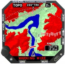
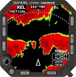
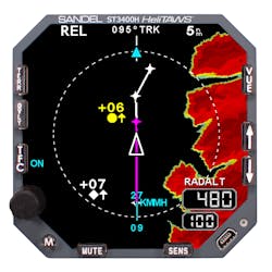
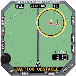
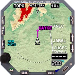
FAA TSO-C194 for helicopter terrain awareness only applies to operations above 500 feet AGL. In reality, however, a great many real-world helicopter operations occur below this level. Sandel Avionics’ ST3400H HeliTAWS system not only is certified for operations below 500 feet, but also exceeds TSO-C194 compliance, according to a company spokesperson. At the same time, the MIL-STD version, the ST3453H Sandel HeliTAWS, is designed to meet military demands.
The commercial ST3400H Sandel HeliTAWS multihazard avoidance system for helicopters protects against terrain, wires, and obstacles, and is certified for nuisance-free operation below en route altitudes. Sandel HeliTAWS incorporate Sandel WireWatch onboard wire-strike avoidance capability, TruAlert technology to eliminate nuisance alerts, and pilot-selectable modes of operation. The ST3453H model adds MIL-STD-3009 NVIS, MIL-STD-810E environmental qualification, and a built-in MIL-STD-1553B bus interface to the commercial version’s features.
Designed for such demanding missions as HEMS, oil rig operations, tactical military support, airborne law enforcement, firefighting, and search & rescue, Sandel HeliTAWS systems are automatic and do not require pilot management of the phase of flight. HeliTAWS also boast an easy-to-interpret, color, high-resolution display for 3D terrain, obstacles, flight plan, and traffic overlay, as well as on-demand NVIS compatibility.
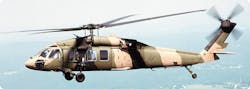
Officials at Sikorsky Aircraft Corp. in Stratford, Conn., selected this new MIL-STD version of Sandel’s COTS wire and terrain alerting system for forward-fit installation aboard the company’s S-70i Black Hawk helicopter.
Sandel Avionics also has begun delivery of MIL-STD-810G-qualified Sandel ST3453H HeliTAWS systems to Korea Aerospace Industries (KAI) in South Korea. Sandel is under a long-term supply agreement with KAI to provide the HeliTAWS multihazard avoidance systems for factory installation on new KAI helicopters manufactured in Korea, including KUH-1P models for the Korean National Police.
“Having KAI include our HeliTAWS system is yet another example of the OEM’s dedication to helicopter safety and ensuring that it’s the number one priority in helicopter operations,” says Sandel President and CEO Gerry Block. “We are extremely proud to work with manufacturers like KAI to increase the availability of technologies designed to make flying safer.”
To start, KAI is equipping its KUH-1P model with HeliTAWS, enhancing the capability of the Korean Utility Helicopter derivative designed specifically for airborne law enforcement requirements.
Flexible functionality
Whether it is emergency medical services (EMS), law enforcement, search and rescue, or any number of other demanding mission profiles, the very nature of a typical helicopter mission means the aircrew must operate in potentially dangerous environments, describes a spokesperson at Rockwell Collins in Cedar Rapids, Iowa. To increase situational awareness and boost safety, Rockwell Collins launched its HeliSure product line at the Paris Air Show in June 2013.

Rockwell Collins engineers designed the HeliSure family of products to provide helicopter pilots with unprecedented situational awareness to help them meet the challenges of flying in increasingly congested and hazard-filled airspace. To that end, HeliSure delivers sensor data in real time through an intuitive user interface that features 3D visualization for information that pilots can easily, quickly, and effectively process.
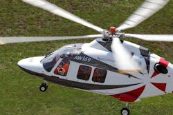
AgustaWestland officials have already selected Rockwell Collins HeliSure devices for the company’s AW149, AW189, AW101 and AW169 platforms. To date, the HeliSure family includes the Helicopter Synthetic Vision System (H-SVS) and Helicopter Terrain Awareness and Warning System (H-TAWS).
The HeliSure H-SVS matches the outside world and meets operator requirements for improved situational awareness, particularly in degraded visual environments, where an accurate understanding of the surrounding terrain becomes critical, according to a company representative. Rockwell Collins’ H-SVS features a high-resolution terrain and known obstacle database, three-arc second resolution through all phases of flight for detailed synthetic vision, and an integrated software application able to be ported to most current-generation, large-format displays.
The HeliSure H-TAWS product enhances mission safety by providing pilots with advanced warning about dangers along their flight path. Able to graphically depict terrain and known obstacles, HeliSure H-TAWS addresses the proposed FAA mandate for the use of an H-TAWS system by helicopter EMS operators, says the spokesperson.
Rockwell Collins also offers its Head-up Guidance System (HGS), a commercial head-up display (HUD), for enhanced situational awareness and energy management in visual flight rules (VFR) and instrument flight rules (IFR) flight conditions. HGS is designed to eliminate the need for pilots to continually transition from head-down instruments to head-up, out-the-window view during critical phases of flight.
Future
The helicopter industry is continuing to grow, Ververs acknowledges, “and Honeywell’s recent helicopter forecast showed that deliveries and demand for helicopters will grow well into 2017 and beyond.
“Air travel is set to double during the next 20 years,” Ververs adds. “The higher volumes of air traffic will require increased situational awareness for pilots to safely navigate more crowded skies and airports and do so in a safe and timely manner.” To that end, industry and government entities are working together to advance cockpit technologies and, ultimately, make flights ever more efficient, environmentally friendly, affordable, and safe.
Eliminating visual clutter
“With its touchscreen controls that work with most flight gloves, G5000H eliminates visual clutter. Mechanical knobs, buttons, and selector switches have been replaced with a series of large, landscape-oriented, high-resolution displays,” explains Brett Harlow, military/government aviation business development manager at Garmin International in Olathe, Kan. Each display can function independently as a primary flight display (PFD) or multifunction display (MFD), and operate in multi-pane mode, enabling flight crew to two pages side-by-side on a single display. “You can choose to view your primary flight display, maps, charts, checklists, synoptics, HTAWS, flight planning, weather, or video input side-by-side on any of the displays.
The PFD’s wide-screen aspect ratio provides a panoramic view of Garmin’s Helicopter Synthetic Vision Technology (HSVT), which enhances situational awareness by creating a “virtual reality” depiction of ground and water features, obstacles, and traffic in proximity to the aircraft, Harlow continues. “You get a realistic picture of what lies beyond the nose of your helicopter—even in solid IFR or nighttime VFR or low-visibility conditions.”
An optional HTAWS in the G5000H predicts in advance where potential hazards may lie and alerts the crew should they pose a threat, Harlow describes. “The five-color Terrain Proximity display makes it easy to see just how close you are to a potential threat, while voice callouts announce the helicopter’s height above terrain while descending below 500 feet. And ADS-B enhanced traffic collision avoidance alerting allows you to see what ATC sees, thus allowing you to steer clear of other aircraft.”