BP and AeroVironment launch first FAA-approved, commercial unmanned aircraft operations over land and water
PRUDHOE BAY, Alaska, 12 June 2014. BP Exploration (Alaska) Inc. engineers selected AeroVironment (NASDAQ:AVAV) to provide mapping, geographic information system (GIS), and other commercial information services at its Prudhoe Bay oil field, the largest oil field in North America, for a five-year period.
This contract marks the first time unmanned aircraft systems (UAS) will perform routine commercial services over land in compliance with Federal Aviation Administration (FAA) regulations.
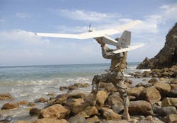
AeroVironment’s information solution includes its Puma AE UAS equipped with either its standard electro-optical and infrared sensor payload or a custom integrated LiDAR (Light Detection and Ranging). The sensor payloads produce imagery and data for processing into 3D computerized models of roads, pads and pipelines, and other actionable information, including precision volumetric measurement and topographic analysis of gravel pits at the North Slope field. Commercial UAS operations began on June 8, 2014.
“Thanks to the FAA’s rigorous, safety-focused certification process for UAS, BP and AeroVironment have launched a safer, better and more cost-effective solution for managing critical infrastructure and resources,” says Tim Conver, AeroVironment chairman and chief executive officer. “BP’s forward-thinking embrace of UAS technology enabled AeroVironment to deliver a comprehensive approach for generating, processing, and converting data collected by portable UAS into actionable information that provides tangible economic and operational advantages. Integrated into BP’s routine operations, this new solution is now helping BP manage its extensive Prudhoe Bay field operations in a way that enhances safety, protects the environment, improves productivity and accomplishes activities never before possible.
“This is an important achievement for our joint team and for the industry in demonstrating the safe and effective use of our proven UAS technology for commercial applications. Our team has established a model for delivering this flexible and efficient information service, including back office data processing, to a wide variety of customers and industries throughout the world for whom better information, safety and reliability matter,” Conver adds.
AeroVironment's operational track record includes the production and delivery of nearly 25,000 new and replacement small unmanned aircraft with cumulative flight time estimated at more than one million hours. The company has delivered its small UAS to customers in the United States and in more than 30 allied nations.
BP’s IT&S Chief Technology Office pursued the application of unmanned aircraft systems technology to enhance BP’s oil and gas operations. Recent FAA restricted category aircraft type (RCAT) certificates for Puma AE and a larger UAS over water were the first for UAS in the national airspace systems (NAS). BP defined its mapping needs for the Alaska North Slope and issued a request for information in June 2013 to multiple geographic information system (GIS), manned and unmanned aircraft systems companies. BP selected AeroVironment’s response and invited the company to perform a proof-of-concept demonstration.
AeroVironment demonstrated mapping and inspection services incorporating UAS at the Prudhoe Bay field in September 2013 under a public certificate of authorization through the University of Alaska Fairbanks. These services included 3D road mapping, 3D gravel pit volumetric analysis, visual and 3D pipeline analysis, general topography, and environmental monitoring services, and demonstrated the ability to support wildlife protection, ice floe monitoring, search and rescue and oil spill response. The team also demonstrated inspection of critical infrastructure, including flare stacks, tanks, bridges, and power lines.
As part of a comprehensive data collection, processing and reporting solution, AeroVironment integrated a LiDAR sensor payload into its battery-powered Puma AE UAS. AeroVironment’s UAS operators are now performing photogrammetry and LiDAR analysis to survey Prudhoe Bay infrastructure including the gravel roads, pipelines and a gravel pit. The Puma AE’s ability to fly low, at 200 to 400 feet above ground level, and slowly, at less than 40 knots, provides BP with highly accurate location analytics capabilities to help manage its complex. The Puma AE is capable of up to 3.5 hours flight time per battery and has a wingspan of about nine feet.
In one application, surveying the 200 miles of roadways built to support North Slope activities is critical to the effective operation of the Prudhoe Bay field. Drill rigs that traverse the roadways span up to 28 feet wide, 132 feet long and weigh up to 3.5 million pounds, with a driver at each end. The highly accurate LiDAR-produced maps delivered by AeroVironment’s Puma AE, along with precision GPS guidance systems, assist drivers in keeping moving drill rigs centered on the roadways, even in low visibility conditions.
The Puma AE UAS is well suited for operations in sensitive ecological areas because of its electric propulsion, low acoustic signature, and small operating footprint. AeroVironment’s UAS services will help improve the safety and reliability of BP’s Prudhoe Bay infrastructure and maintenance programs, which accounts for about two-thirds of Alaska oil production.

