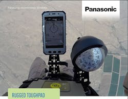
Airborne Systems taps Panasonic rugged tablet to help parachutists navigate in air
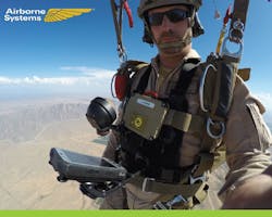
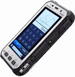
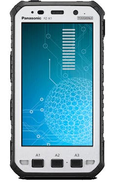
Airborne Systems’ staff selected the Panasonic Toughpad FZ-X1 rugged handheld tablet for its daylight- and night time-readable screen and its ability to withstand water, extreme temperatures, and high altitudes. With the combination of Airborne Systems’ navigation software application and Panasonic’s Toughpad, military parachutists now have a reliable device to help them safely navigate jumps, while providing valuable assistance for missions on the ground.
Military service members perform missions all over the world in the most extreme environments imaginable. Whether by air, land, or sea, they need reliable technology that is up to the job.
Airborne Systems is a parachute company that supplies military customers with the equipment needed to safely execute jumps from planes and helicopters during a variety of missions across the globe. Airborne Systems has expanded its portfolio by developing a navigation system to help military parachutists navigate and land safely in extreme environments.
"During high-altitude jumps up to 30,000 feet in the air, our customers can be jumping at night, in the clouds, and have no idea where they are in the sky," affirms Vincent Mignot, parachute engineer at Airborne Systems. "We needed to create a navigation system to help them determine where they are supposed to land, knowing how difficult that can be with wind and other weather elements."
Initially, Airborne Systems decided to try manufacturing their own system in-house – including everything from the computer to display screen to the sensors.
"We struggled a lot," Mignot recalls. "We weren't able to create nice displays and the screen wasn't the right resolution, making the data hard to read.”
The company decided to integrate their navigation program with an off-the-shelf mobile computer. Airborne struggled with compatibility issues between their navigation software and the new computer. Then, after coming up with a solution to the problem, the manufacturer modified their computer a few months later and Airborne had to start all over again.
"We realized that off-the-shelf products are good but they're not really stable; they change a lot, and every time they change something, there's the risk that our solution might not work anymore," Mignot says.
That's when Mignot and his team began to look for a rugged mobile computer to support the navigation system. Airborne Systems' "Pilot" solution measures data such as wind speed, altitude, and the user's distance from the target. It also enables jumpers to view a map to see where they are located as well as where their fellow jumpers are located in the sky relative to their location. "Pilot" is also equipped with a Wi-Fi connection and a radio to allow jumpers to broadcast location and other information to their team.
To run the "Pilot" solution, Airborne needed a handheld device with reliable connectivity that parachutists could easily operate mid-jump. Not only did the device need to be user-friendly, but it was imperative that the device could withstand the conditions of a jump and provide a readable-screen in both direct sunlight and complete darkness to safely navigate parachutists to the ground.
Airborne Systems turned to leading IT systems integrator Bizco to identify the right device to support the navigation system. Bizco lent Airborne several rugged devices to use in testing, including the Panasonic Toughpad FZ-X1 rugged tablet.
"We looked at several different companies offering rugged computers with a 5-inch screen," Mignot describes. "We quickly realized Panasonic was the best – the quality of the screen, resolution and daylight-readability when jumping were all important to us. During jumps it can be very bright, and when testing the other devices, we couldn't see anything on the screen. The Toughpad was easy to read and we were never really able to damage the devices during testing."
With resistance to drops of up to 10 feet to concrete, the Toughpad FZ-X1 goes beyond MIL-STD-810G specifications to assure in-field reliability. It is sealed against dust and is submersible in up to 5 feet of water for up to 30 minutes, meeting IP65 and IP68 certification requirements. It can withstand an operating temperature range of -4°F to 140°F thanks to a built-in heater, and is tested for resistance to impact, shock, vibration, altitude, and extreme humidity.
In addition to its rugged design, the Toughpad FZ-X1 features a high-sensitivity 10-point capacitive multi-touch display that works with heavy gloves, or in pouring rain. Powered by a 14-hour hot-swappable battery, it also serves as a dependable and lightweight handheld tool to help complete missions once the user lands safely on the ground. The small, lightweight design of the Toughpad combined with its ultra-rugged design made it the perfect tool that jumpers could trust to land them safely during any mission, officials say.
"By far our customers all prefer the Panasonic device," Mignot admits. "A lot of customers ask if the device is IP certified and Mil-Spec tested – that's very important to them. If you jump at night and land in a war zone or the middle of a desert, and your navigation system stops working, you're in big trouble."
After successful testing, Airborne Systems purchased four Toughpad FZ-X1 rugged tablets earlier this year, and recently ordered an additional 20 devices to equip new navigation systems.
You might also like:
Subscribe today to receive all the latest aerospace technology and engineering news, delivered directly to your e-mail inbox twice a week (Tuesdays and Thursdays). Sign upfor your free subscription to the Intelligent Inbox e-newsletter at http://www.intelligent-aerospace.com/subscribe.html.
Connect with Intelligent Aerospace on social media: Twitter (@IntelligentAero), LinkedIn,Google+, and Instagram.
