Locata and Air Force develop advanced navigation system impervious to GPS jamming, electronic warfare
WRIGHT-PATTERSON AIR FORCE BASE, Ohio. The Air Force Institute of Technology at Wright-Patterson Air Force Base (AFB) in Ohio and Locata Corp. in Australia developed, under a Cooperative Research and Development Agreement (CRADA), and delivered an accurate navigation system capable of performing in the face of electronic warfare (EW), including wide-area global positioning system (GPS) jamming.
The 746th Test Squadron at Holloman AFB, New Mexico, required a highly accurate navigation system for testing methods developed for overcoming GPS jamming and other forms of electronic warfare. This system is tested on equipment, such as aircraft or land-based vehicles, that are used in locations where electronic warfare prevents the warfighter from using GPS in battle.
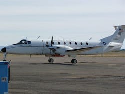
A United States Air Force aircraft, fitted with Locata antenna and receiver, taxies at Alamogordo Airport before taking off to test the performance of the Locata network installed at the White Sands Missile Range, New Mexico. The Air Force Institute of Technology was chosen by the 746th Test Squadron to partner with the Locata Corporation through a Cooperative Research and Development Agreement to develop a highly accurate navigation system for testing methods developed for overcoming GPS jamming, or electronic warfare. This collaboration allowed AFIT to provide research and government expertise for updating Locata’s system. The updates included new antennas for aviation use, amplifying the Locata transmitter signals for longer ranges and determining the additional dynamics associated with aircraft, such as speed, maneuverability and tropospheric variation adjustments. (Courtesy Photo/Locata Corporation)
The Locata Corp., headquartered in Canberra, Australia, developed a commercially-available network system that provided highly accurate, terrestrial position, navigation, and time (PNT) solutions in environments with or without GPS. However, the Air Force requirement covered a larger geographic area than the Locata technology was originally designed to support and required additional updates.
Since AFIT had experience with modeling errors and atmospheric delays on larger networks, they were chosen by the 746th Test Squadron to partner with the Locata Corp. through a CRADA. This collaboration allowed AFIT to provide research and government expertise for updating Locata’s system to meet the requirements developed by the 746th Test Squadron. The updates included new antennas for aviation use, amplifying the Locata transmitter signals for longer ranges, and determining the additional dynamics associated with aircraft, such as speed, maneuverability, and tropospheric variation adjustments.
“The AFIT updates to the Locata system provide accuracy in a GPS-jammed environment that approaches the best we can get in a clear-air environment. We are currently using this system to test the DoD’s next generation navigation systems,” said Jim Brewer, 746th Test Squadron, Holloman, AFB.
The updated Locata system was tested on military GPS equipment which can also utilize M-Code signals, or military signals, that assist with encryption by providing a more secure signal than previous technology.
Tests of the updated navigation system were conducted at White Sands Missile Range, New Mexico, by the 746th Test Squadron.
Through the CRADA, AFIT had access to the challenges associated with building a real system versus building simulations. In addition, researchers had exposure to relevant research that was only made possible through the agreement.
"This collaboration provided Locata with access to a large military base and aircraft so extremely long-range Locata systems could be tested and verified,” says Paul Benshoof, business development manager, Locata Corp.
Search the Aerospace & Defense Buyer's Guide
The go-to resource for Intelligent Aerospace technology news & information:
Covering key topics
Across all market segments
Subscribe to the free Intelligent Inbox e-newsletter
Subscribe to receive all the latest aerospace technology news & information, delivered directly to your e-mail inbox twice a week (Tuesdays and Thursdays). Sign upfor your free subscription to the Intelligent Inbox e-newsletter at http://www.intelligent-aerospace.com/subscribe.html.
Connect on social media
Keep pace with aerospace innovation and opportunities via your favorite social media channels. Connect with Intelligent Aerospace on Twitter (@IntelligentAero), LinkedIn,Google+, and Instagram.


