USRA's Earth from Space Institute to join space-based response to COVID-19
COLUMBIA, Md., - Universities Space Research Association (USRA) announced today the selection of Dr. Miguel Román, Director of The Earth from Space Institute (EfSI) and his research team as recipients of a grant from NASA's Earth Sciences Division. The purpose of this grant is to use data collected from Earth-observing satellites to improve understanding of the effects of the COronaVIrus Disease (COVID-19) in urban areas.
Competitively selected from among several research proposals submitted to NASA, USRA scientists and university collaborators will be harnessing the power of Earth observations in support of COVID-19 monitoring, response, and recovery efforts. The resulting information will be made available to decision-makers consistent with NASA's open sharing of data and information.
Dr. Miguel Román serves as principal investigator of NASA's Black Marble research team. The group is producing science-quality nighttime lights data obtained from the Suomi-NPP and NOAA-20 platforms – the next generation of US Polar-orbiting Satellites. The study will make use of Black Marble data to assess the social, economic, and cascading impacts of COVID-19 and other events, and the effectiveness of actions taken at community, national, regional, and global levels to mitigate their adverse effects and build greater resilience through response measures.
For example, there is currently minimal data on how different containment strategies have affected local businesses and neighborhoods, and how companies and citizens are responding to preventative measures aimed at containment. "Decision-makers require detailed, timely, and accurate information on socio-economic disruptions and recovery during the COVID-19 epidemic," said Kai-Alexander Kaiser, Senior Economist at The World Bank Group Global Governance Practice, who is a collaborator on the project. "And they want to know how to better inform strategies for mitigating potential future breakouts and cascading impacts on systematically underrepresented and underserved populations."
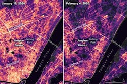
Since early February 2020, Dr. Román and his team have been analyzing nighttime images collected by the Visible Infrared Imaging Radiometer Suite on-board the Suomi-NPP and NOAA-20 to decipher changes in urban business, industry, and transportation activity patterns during the Pandemic, providing new insights for COVID-19 risk reduction and resilience efforts. As a result of these efforts, the research team was able to observe the early signs of the shutdown when highways and commercial centers went dark around Hubei province in central China.
As reported by the media and U.S. State Department, Chinese authorities suspended air, road, and rail travel in the area, and placed restrictions on other activities in late January 2020 in response to the COVID-19 outbreak in the region. According to Dr. Román, "We are working on routine production of multi-sensor data and analysis tools that will take our applied use case in Hubei Province, and expand it further to assess how different countries and economic sectors have responded to COVID-19 containment and quarantine recommendations."
Spatially-explicit monitoring, available in near-real time at the street level, is also essential for identifying where to send aid, and for understanding distributional impacts – specifically "who" has been most affected and "what" is the capacity of the affected communities to cope. "We anticipate that expedited access to NASA's Black Marble product will be vital not only for the ongoing COVID-19 pandemic, but also to improve other hazard monitoring needs in Latin America and the Caribbean," said Katie Taylor, Executive Director of the Pan American Development Foundation (PADF) and a collaborator on this project. "The findings that emerge from this analysis will undoubtedly strengthen national-level hazard monitoring and local-level communities to build greater resilience and improve early warning systems in the region."
