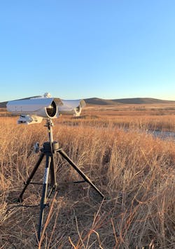
Novel vision system autonomously detects and identifies drone threats
ATLANTA - Commercial and recreational drone usage has skyrocketed in recent years as the technology has become less expensive and easier to use. From infrastructure inspection and emergency response to filmmaking and hobbyist photography, drones have a vast, growing range of applications. Unfortunately, drones can also represent threats — whether intentional or not. In places where drones pose a threat, such as airport, prison, border patrol, and military scenarios, airspace security becomes paramount.
Fortunately, as drone technology has advanced, so too have drone detection capabilities. Radio frequency sensors, radar, acoustic sensors, cameras, and other technologies are typically used for such tasks. Some technologies even offer autonomous capabilities.
Drone Threats Emerge
In the United States alone, the number of drones registered with the Federal Aviation Administration is approaching one million, with 314,689 commercial dronesExamples include flying too close to restricted airspace, dropping contraband into prison yards, transporting drugs across borders, carrying out prohibited surveillance and reconnaissance, and even dropping small bombs or explosives. Recognizing threats and implementing security practices that meet federal, state, and local regulatory requirements are crucial steps in successfully managing potential security incidents associated with drones, according to the Cybersecurity & Infrastructure Security Agency.
There are several methods for mitigating risks, starting with researching and implementing a legally approved counter-drone technology and understanding the air domain around a facility or area. Autonomous detection systems such as Walaris’ AirScout Sentry combine industrial cameras, powerful edge processing, and proprietary computer vision and artificial intelligence algorithms (AI) for optical detection capabilities in critical applications.
Autonomous Threat Detection
Depending on the application requirements, the hardware-agnostic AirScout may deploy cost-effective cameras from Axis or Bosch or use other off-the-shelf multispectral or infrared imaging cameras for longer range deployments. Walaris’ AirScout Sentry offers a complete detect-track-identify solution, while companies looking to use other detection modalities, such as radar, can utilize AirScout Verify, a slew-to-cue tracking and identification software solution.
Each AirScout Sentry deployment of the system involves several detection cameras that continuously monitor an area of interest. Detections from those video streams are passed to a verification camera, which confirms the threat and alerts operators or rejects false-positive detections. If the AirScout Sentry software detects relevant data such as birds or a drone, it captures the object’s coordinates. A pan-tilt-zoom algorithm triggers a camera to zoom in on the coordinates to further investigate the object while AI and range-to-focus control algorithms allow the system to find the target, maintain a clear image, and classify, identify, and track it.
Once the system classifies an object as a drone, it provides an alert to the system operator, along with a full-motion video with the classification determination.A Clean Data Acquisition Pipeline
Classifying drones with a high degree of confidence presents several challenges. These are small objects moving quickly and at a distance, clutter may be present in the area of interest, and drones may be flying across complex backgrounds, according to Kyle Meloney, Cofounder and CEO of Walaris in Atlanta.
“Using beyond-state-of-the-art AI algorithms allows the system to make an optical classification in near real time and with limited optical information but getting to this point requires a lot of preparation when it comes to the data,” he said.
AirScout’s AI algorithms continuously train on a growing dataset. Walaris’ data acquisition pipeline involves acquiring images and cleaning that data to ensure that all images are properly labeled, such that the training process uses high-quality images to better train their models.
“Our training process is perpetual,” Meloney said. “We are constantly adding clean, labeled images to the dataset and improving upon the algorithms over time, so the system works more effectively over time.”
Powerful Edge Processing for Potent AI
At the heart of the overall AirScout system is the software, which features the proprietary detection, classification, and PTZ algorithms, among others. Earlier optical detection methods involved looking for motion and/or contrast in an image. This technique works well in simple scenarios, but complications arise when the scene becomes more complex, according to Meloney.
“If a drone is flying across a cloudy sky and birds are present in the scene, then a lot of motion and varying levels of contrast exists and it can become difficult to pick out the drone,” he said. “By processing the entire image in near real time and tagging every single object to determine its relevance, we can reduce false positives and automate the detect-track-identify response chain.”
Running complex AI algorithms requires powerful processing capabilities, so Walaris sourced a custom-configured industrial PC from CoastIPC with an NVIDIA graphics processing unit (GPU) to run the AirScout software.
“Mission-critical applications require reliable, robust PCs,” said Meloney. “Every PC supplied by CoastIPC has come on time and fit the exact requirements we specified to deliver and execute on every mission without failure.”
Eyes in the Sky
The market offers several methods for drone detection, and no one option is necessarily the best possible solution. For those looking to take a hands-off and comprehensive approach, however, systems that leverage cameras and AI software can deliver full-stack solutions for detecting, tracking, and identifying drones in dynamic environments.


