Mars lander deploys electronic instruments, despite initial computer glitches
PASADENA, Calif.—Since the NASA Phoenix Mars Lander was deployed, NASA engineers from the Jet Propulsion Laboratory (JPL) in Pasadena, Calif., are pleased with the performance of the mission’s electronic instruments, despite two minor bumps.
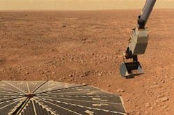
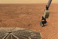
After landing, Phoenix sent back a panorama photograph of the Martian surface, deployed its 8-foot robotic arm, tested a laser for studying dust and clouds, and transmitted a weather report.
“We’ve imaged the entire landing site, all 360 degrees of it. We see it all,” says Phoenix principal investigator Peter Smith of the University of Arizona in Tucson, Ariz. “You can see the lander in a fish-eye view that goes all the way out to the entire horizon. “We are now making plans for where to dig first, and what we’ll save for later.”
Ground technicians at the JPL sent commands for Phoenix to twist its mechanical arm’s wrist, raise its forearm, and straighten the robotic arm to free its elbow restraint.
“We’re pleased that we successfully unstowed the robotic arm. In fact, this is the first time we have moved the arm in about a year,” says Matthew Robinson of NASA JPL. “We have achieved all our engineering characterization prerequisites, with all the critical deployments behind us,” says JPL’s Barry Goldstein, Phoenix project manager.
Next comes hot and cold testing of the lander’s robotic arm, and the arm will use a camera to photograph the Martian surface underneath the lander. Eventually the arm will dig a trench into layers of ice beneath the Martian soil and analyze a soil sample for its mineral and water content, and its suitability to support life.
The Mars lander will use a laser-based light detection and ranging (LIDAR) instrument from the Canadian Space Agency to look for dust, clouds, and fog with a green laser. “One of the main challenges we faced was to deliver the lidar from the test lab in Ottawa, Canada, to Mars while maintaining its alignment within one one-hundredth of a degree,” says Jim Whiteway Canadian Science lead from York University, Toronto. “That’s like aiming a laser pointer at a baseball at a distance from home plate to the center field wall, holding that aim steady after launch for a year in space, then landing.”
Lidar detects dust to an altitude of two miles. The weather at the Phoenix landing site on the second day following landing was sunny with moderate dust, with a high of minus 30 degrees Celsius and a low of minus 80 C.
Early last month, Phoenix was having trouble getting soil samples into its analyzer. One of the main goals of the Phoenix mission is testing for water in the Martian soil. The first soil samples collected by the robotic arm did not initially make it into the oven for testing, creating a lot of anxiety for Phoenix engineers.
Eventually the soil made it into the Thermal and Evolved-Gas Analyzer, or TEGA, which bakes and sniffs the Martian dirt looking for volatile ingredients like water. “There’s something very unusual about this soil, from a place on Mars we’ve never been before,” Smith says. “We’re interested in learning what sort of chemical and mineral activity has caused the particles to clump and stick together.”
In mid June, some concern was raised among the Phoenix engineers regarding flash memory when Phoenix generated an unusually high volume of spacecraft housekeeping data causing the loss of some non-critical science data. Phoenix engineers were analyzing why this anomaly occurred at the time of publication.
Last month, Phoenix computers generated too much data for its flash memory, and lost some science data—mostly photos that can be taken again.
“We can continue doing science that does not rely on non-volatile memory,” Goldstein says.

