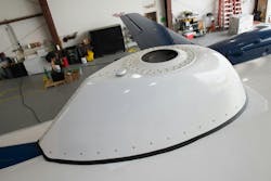
Draper completes flight tests of GPS-alternative navigation technologies
CAMBRIDGE, Mass. - Draper in Cambridge, Masss., recently concluded a series of successful flight tests of its Assured Positioning, Navigation, and Timing (APNT) technologies, including its airborne celestial navigation system (CNS), as part of ongoing efforts to develop alternatives to the Global Positioning System (GPS) for military and aerospace applications.
The tests were conducted over more than 30 flight hours aboard a twin turboprop aircraft, flying in both day and night conditions at altitudes up to 25,000 feet. Draper’s CNS unit, a 1.5-cubic-foot line replaceable unit (LRU), demonstrated navigation accuracy within 30 meters and operated in an unpressurized, unconditioned compartment. The device is qualified to meet MIL-STD-810 and MIL-STD-461 environmental standards.
"The test results show that a producible airborne CNS can meet operational requirements and is ready for integration into customer platforms," said Scott Dellicker, director of GN&C Solutions at Draper. "This is an important development for our customers’ ability to maintain freedom of maneuver in highly contested and challenging environments."
The CNS uses Draper’s Skymark technology, a form of celestial navigation designed for use in GPS-denied and degraded environments. Originally developed for aircraft and missile guidance, Skymark is now being adapted for ground and space vehicles as well. A version of the technology is already in production for the U.S. Navy’s Arleigh Burke-class destroyers.
Vision PNT
The flight campaign also tested other systems from Draper’s "Anytime, Anywhere, Any-threat Position Navigation and Timing" (A3PNT) portfolio, which includes multiple modalities designed to function in denied environments.
Among them was Draper’s vision-aided navigation (VAN) system, which uses visible and infrared imagery to maintain navigation without GPS. According to Draper, VAN has supported operations from altitudes of 100 meters to 100 kilometers and was tested under challenging conditions, including high-altitude night flight and over-water navigation.
Another system evaluated was the Signals of Opportunity (SOOP) unit, which collects radio frequency signals from low Earth orbit satellite internet constellations using a Ku-band receiver. The SOOP system, designed to operate with low size, weight, and power demands, enables Doppler-based navigation using non-traditional radio frequency (RF) sources.
"This internally funded test flight demonstrates our commitment to producing alternatives to GPS in highly contested and challenging environments," said Chris McDowell, director for Assured PNT Solutions at Draper. "As related technologies continue to mature, our portfolio of A3PNT options will expand further, lessening our dependence on GPS and enabling operations across multiple domains and platforms."
About the Author
Jamie Whitney
Senior Editor
Jamie Whitney joined the staff of Military & Aerospace Electronics in 2018 and oversees editorial content and produces news and features for Military & Aerospace Electronics, attends industry events, produces Webcasts, and oversees print production of Military & Aerospace Electronics.
