Enabling technologies for port and harbor security
The United States has always depended on water transport to import, export, and distribute goods. As the nation expanded from 13 East Coast colonies to a nation ranging from Maine and the U.S. Virgin Islands in the East to Alaska and Guam in the West, the movement of goods by ocean and rivers became even more important — and remains so to this day.
America has 25,000 miles of navigable rivers, 159 ports responsible for moving more than 99 percent of annual U.S. import/export goods and 1,500 harbors (all ports are harbors, but only a fraction of harbors are ports). These cover a distance of roughly 9,500 miles East to West and 3,000 miles North to South — or 28,500,000 square miles.

Because many of these waterways, such as the Great Lakes, Gulf of Mexico, and the Caribbean also border Canada and Mexico, this effort requires international cooperation and coordination.
Leading the U.S. security system for navigable waterways, ports, and harbors is the U.S. Coast Guard, which is the 12th largest naval force and 7th largest naval air force in the world. Although it is one of the nation’s seven uniformed services, it is part of the U.S. Department of Homeland Security, not the U.S. Department of Defense (DOD). Portions of the Coast Guard, however, can be assigned temporarily to DOD, under the U.S. Navy, in wartime or for special assignments, such as anti-piracy patrols around Africa.
“The Coast Guard has a mandate for providing maritime security and has a research and development center in Groton, Conn.,” points out Lt. Cmdr. Blair Sweiggart, chief of the Coast Guard’s enforcement division in the Puget Sound, Wash., sector.
Coast Guard concerns
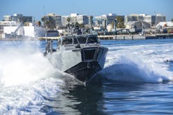
Among the Coast Guard’s chief national security concerns is identifying and tracking small boats and so-called “dark” vessels — those that operate without radar transponders, or that disable transponders by reporting false identities or locations. “For the last two years, we have been working with our counterparts throughout DHS, as well as the Royal Canadian Mounted Police, looking at radar contact on small and dark vessel detection, Sweiggart says.
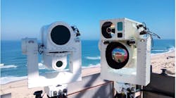
Rapidly evolving technology has become a critical force multiplier; unmanned aircraft, surface vessels, and submarines and short-range surface-search radars can provide 24/7 on-site physical data to high-speed processors incorporating machine learning that alert human security personnel to confirmed or potential problems.
Such systems are just being deployed or still in testing, but their influence already is being seen. “What we’ve already seen, on our radar system, is enhancing our maritime situational awareness allows us to be smarter about where we deploy our manned resources, which serves as a force multiplier,” Sweiggart says. “From a security standpoint, we can retain the required level of awareness while keeping our manned assets in garrison or using them for other missions. Any waterway is exploitable. We certainly see that along the maritime border here, where we have about 135 miles of border, over much of which no one agency has the manpower to have constant access.”
Technology is the key enabler to maintain situational awareness. “That is true throughout the ports and harbors in this region, which comes down to really good partnerships,” Sweiggart continues. “Those waterways also are where some softer targets are, such as the Washington State Ferry System, which is the largest ferry system in the world. Working with our partners, using risk-based modeling and coordinated schedules and facilities, allows us to more efficiently counter those threats.”
International concern
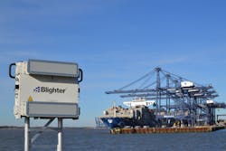
Waterway security is an international concern, with some of the leading security system and equipment providers located in Europe, the Middle East, and Asia. One such is Blighter Surveillance Systems in Great Chesterford, England, which produces electronic-scanning (e-scan) ground radar systems for counter-drone, perimeter security, wide-area surveillance and coastline security applications.
Blighter Chief Technology Officer Mark Radford says his company’s radars look for small, slow-moving targets, while traditional coastal radars typically scan for larger boats and ships further from shore.
“[Blighter uses] Doppler radars, so they detect the movement of objects; they also are frequency-modulated, continuous wave, which allows us to detect targets at very short ranges, as close as 10 meters,” Radford explains. “Traditional radars are blind for up to 500 meters, some up to seven kilometers. Our short range means we can detect a small boat that may have a radar cross-section as small as one square meter. We can detect it close to the shore and when the occupants get out and start walking on the beach, we can continue to follow them.
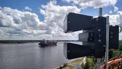
Other technologies help give the Blighter radar a tight focus on close-in vessels. “As with all radars, they need to be placed
Ku band radars provide an all-weather, day/night capability and typically pair with long-range daylight cameras and thermal imaging cameras at night. Blighter‘s system, originally was designed as a ground radar, then modified for use over water, also can detect low-flying UAVs, especially in a cluttered environment.
“It is key to integrate with sonar systems to cover underwater activities,” Radford points out. “For instance, in South Korea, we have more than 100 of our units along the DMZ, most on land, but also along islands just offshore that the DMZ extends to. With that, we have been able to detect swimmers coming from North Korea.”
Blending information from several different sensors key be key in harbor and waterway security. “Today’s primary port, harbor and river security technologies are radars, cameras, thermal imagers and sonar, a combination of electromagnetic and acoustic spectrums,” Radford explains. “With a port or perimeter area, you also would have a [physical] wall or fence line. All of the sensor systems ultimately link into a command and control center that allows you to set up alert zones on the mapping system.”
Enhancements to all of those, along with the deployment of new or advanced technologies still under development, will improve coastal and river security significantly in the next five years, he adds.
Blending sensors
“The key driver we’re seeing is the move from individual single-function sensors, such as coastal protection or ground radars, and combining them into one radar system. We can now do mixed sea and ground sensing, as well as low-flying UAVs, which have changed the challenge from 2D to 3D,” Radford says.
Of the three waterway domains, many consider harbors — generally larger targets than developed ports — to be the most vulnerable to terrorist attacks. As natural formations, often used for centuries, they are more defined by the land enclosing them, making them more difficult to protect in a cost-effective manner. Natural curves in their environment create shadows and large areas that are unprotected because local authorities cannot afford the additional radars that would be required. Smaller, less expensive short-range radars can create a day/night, all-weather defense to enhance harbor protection significantly, especially when combined with other mechanisms, such as UUVs and electronic fences.
U.S. and allied installations overseas have been the targets of thousands of aggressive UAV operations in recent years. Officials say such incidents may be stand-alone efforts to penetrate maritime and land defenses — or distractions supporting other illegal activities on or under water, in the air or on land.
“So your radar and sensor system needs to do more than one thing, not just tracking a drone in the air, but continuing to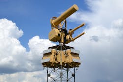
Other sensors include day/night, all-weather EO/IR (electro-optical/infrared) devices that automatically and continuously scan surrounding maritime and land zones for unauthorized activities. Their use in port and harbor security includes:
- creation of an over-water virtual fence to detect small boats and swimmers before they reach the port/harbor boundary;
- creation of an overland virtual fence to detect land intruders before they reach the fence;
- observation of intruders detected by other means;
- identification and tracking of intruders and direction of security forces;
- scanning of waters within the port/harbor boundaries for unauthorized activities;
- surveillance of all ships and boats within the protected area; and
- surveillance of all land fences within the protected area
Arctic protection
A growing area of concern for the U.S. is the vast Arctic, where the U.S. Territorial Waters and Exclusive Economic Zone covers 1 million square miles. The value of this region includes:
a $3 billion economic impact on Alaska’s Arctic seafood industry;
90 billion barrels of undiscovered oil reserves and an estimated 30 percent of the world’s undiscovered natural gas; and
$1 trillion in rare earth minerals, which otherwise are located largely in countries with which the U.S. has tenuous relationships, such as China.
There have been significant changes in the region since release of the 2013 Arctic Strategy, increasing security demands on U.S. capabilities already stretched thin and, in many cases, underdeveloped for the Arctic’s harsh environment.
Although it has no border on the region, China has declared itself a “near-Arctic state” and the region, into which it is making more and more expeditions, a strategic priority. That includes being the origin or destination for 40 percent of the vessels that carried a million tons of goods — such as gas, oil, grain and coal — through the Northern Sea Route in 2017.
Russia, which is a major Arctic nation, also has been extremely active, building large icebreaker surface vessels at a faster rate than other nations and establishing six new military bases in the Arctic zone since 2013.
Its size and strategic position are major reasons for President Donald Trump’s interest in the U.S. buying Greenland from Denmark, another of the eight Arctic Nations, which consist of Canada, Russia, Denmark, the U.S., Norway, Sweden, Iceland, and Finland. Becoming a U.S. territory would enable the development of additional security facilities and the placement of advanced technologies on the Eastern side of the Arctic.
Each of the Arctic Nations has been working hard to increase surveillance capabilities — especially underwater/under-ice — to defend and enhance their position in the region. For example, Canada, recognizing the importance of cross-domain situational awareness, has created the Canadian Arctic Underwater Sentinel Experimentation (CAUSE) project to investigate new technologies for wide area underwater and under-ice surveillance in the Canadian Arctic.
Norway and the U.S. recently signed a bilateral maritime arrangement calling for advanced maritime threat-response collaboration between the two countries to address a wide-ranging list of Arctic challenges.
New tactics
The threat to border security for the U.S. and Canada has led to new tactics and procedures designed to strengthen cooperation and lessen the restrictions on armed U.S. maritime operations on the Great Lakes established after the War of 1812. Under those restrictions, U.S. Coast Guardsmen boarding vessels along the water-line border had to disarm if the vessel drifted into Canadian waters. And U.S. vessels were restricted to one small (even by 1812 standards) cannon.
“That essentially erases what is the imaginary line in the water that could be easily exploited if we didn’t have strong programs, such as Ship Rider, in effect on all navigable waterways between the two nations,” the Coast Guard’s Sweiggart notes.
There is a much smaller maritime component in maintaining security along the Southern border, but new technologies have greatly aided Coast Guard efforts in the Gulf of Mexico, Caribbean, and South Atlantic — especially coastal Florida and Puerto Rico.
The Coast Guard and its partner agencies will need to employ all of those — short-range over-water radar, UUVs, UAVs, USVs, and electronic fences — to counter the activities of criminal organizations that have them outfunded, outgunned and outnumbered.
The shared responsibility for security involves not only international partners, but U.S. federal, state and local agencies — and whatever technologies they may have to offer — as well. That includes the Customs and Border Patrol Air and Marine Operations (AMO), local sheriff offices and police departments, state patrols, port and harbor police and patrols, etc., as well as commercial port and industry partners.
With approximately 1,800 federal agents and mission support personnel, 240 aircraft and 300 marine vessels operating throughout the United States, Puerto Rico and the U.S. Virgin Islands, AMO is the world’s largest civilian aviation and maritime law enforcement organization. It employs a variety of cutting edge technologies to conduct its missions.
Larger ports, such as Seattle, Long Beach, San Diego, Miami, and New York, have significant security systems of their own, yet the sheer volume of vessels and goods moving through these facilities every week means their technologies must operate cooperatively with federal, state and local agencies to ensure the most comprehensive coverage to detect and curtail terrorist and criminal activities.
“The maritime transportation system is still the most prevalent method of moving goods and services in the world. Attacks are for political purposes, disruption, to incite fear, etc. For border security, it’s a much more fundamental consideration that there is usually a [criminal] financial incentive to move things from one side of the border to the other — drugs, money, people, etc.,” the Coast Guard’s Sweiggart explains. “We see the involvement of organized groups and activity stemming from organized crime and cartels from around the world.”
Port and harbor security can be difficult today, and is becoming more complex all the time. “The array of threats against the maritime domain is complex and different actors are looking to exploit different aspects,” Sweiggart says. “Part of the role of all the partner agencies responsible for border security is to remain vigilant against that array of threats, continually assess what those threats are and come up with ways to counter them. We’re certainly on the lookout for the domestic as well as international threat. As we all look at threats like active shooters, international groups coming with a specific attack versus domestic, typically lone wolf shooters, both are threats we have to be ready for.”
About the Author
J.R. Wilson
Contributing Editor Western Bureau
Voice Your Opinion!
To join the conversation, and become an exclusive member of Military Aerospace, create an account today!

Leaders relevant to this article: