Special Operations asks Sierra Nevada for sensor fusion avionics for helicopter degraded visual conditions
Summary points:
- Sierra Nevada will develop and support the Degraded Visual Environment Pilotage System (DVEPS) for safe helicopter operations in obscured conditions.
- DVEPS combines FLIR, radar, and LiDAR to create real-time 3D terrain views for pilots in dust, fog, darkness, and other low-visibility conditions.
- Helmet-mounted displays and real-time obstacle avoidance algorithms enable safe landings in brownout, whiteout, and mountainous terrain.
MacDILL AIR FORCE BASE, Fla. – U.S. Army Special Forces experts needed airborne sensors to land helicopters safely in dust, fog, smoke, rain, snow, and darkness. They found a solution from Sierra Nevada Corp. in Sparks, Nev.
Officials of the U.S. Special Operations Command (USSOCOM) at MacDill Air Force Base, Fla., announced a potential $471.6 million contract to Sierra Nevada on Tuesday for the Degraded Visual Environment Pilotage System (DVEPS).
This helicopter avionics system enhances pilot situational awareness and flight safety in degraded visual conditions like such as dust, fog, smoke, rain, snow, and darkness that obscure visual cues necessary for safe flight -- especially during takeoff and landing.
Sierra Nevada will build these DVEPS avionics subsystems without the infrared camera lens sensor. The contract includes production, sustainment, and contractor logistics support.
Sensor fusion
DVEPS integrates several sensor and display systems to enable military helicopter pilots to maintain spatial orientation and safely operate in zero-visibility or low-visibility conditions.
DVEPS sensors combine forward-looking infrared (FLIR), millimeter-wave radar, light detection and ranging (LiDAR), and others to create a synthetic 3D view of the environment around the helicopter during takeoffs and landings.
Its helmet-mounted display projects sensor fusion data into the pilot’s line of sight. The aircraft's mission computer processes data from sensors to generate images in real-time of nearby terrain and obstacles. Navigation and obstacle avoidance algorithms help the pilot with terrain following and avoiding hazards. hazard avoidance.
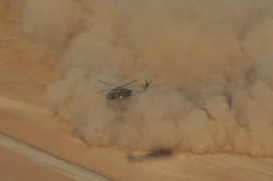
Helicopters often encounter brownout or whiteout conditions when the downdraft from the helicopter's rotors kick-up dust, snow, or other obscurants to prevent the pilot from seeing clearly outside the aircraft.
The DVEPS also works in darkness and bad weather, and helps control the aircraft in mountainous terrain where visual navigation is difficult even in good weather. The DVEPS often is fitted aboard Army helicopters like the UH-60 Black Hawk, CH-47 Chinook, and AH-64 Apache.
On this contract Sierra Nevada will do the work in Sparks, Nev., and should be finished by June 2030. With options the contract could extend to November 2030. For more information contact Sierra Nevada Corp. online at www.sncorp.com, or U.S. Special Operations Command at www.socom.mil.
About the Author
John Keller
Editor-in-Chief
John Keller is the Editor-in-Chief, Military & Aerospace Electronics Magazine--provides extensive coverage and analysis of enabling electronics and optoelectronic technologies in military, space and commercial aviation applications. John has been a member of the Military & Aerospace Electronics staff since 1989 and chief editor since 1995.
Voice Your Opinion!
To join the conversation, and become an exclusive member of Military Aerospace, create an account today!

Leaders relevant to this article: