Sierra Nevada to build synthetic vision helicopter avionics for degraded visual environment (DVE) conditions
ROBINS AIR FORCE BASE, Ga. – U.S. Air Force helicopter avionics experts needed synthetic vision equipment to enable helicopter pilots to land and take off in degraded visual conditions like snow whiteout or dense clouds of dust. They found their solution from Sierra Nevada Corp. in Sparks, Nev.
Officials of the Air Force Materiel Command at Robins Air Force, Base, Ga., announced a $74.9 million contract to Sierra Nevada last week to install degraded visual environment systems (DVES) on 85 HH-60G Pave Hawk helicopters to improve situational awareness for pilots and air crew operating in DVE conditions.
Sierra Nevada's DVES will add new helicopter avionics capabilities to the Air Force HH-60G. This contract provides for procurement, installation, and integration of the DVES on 85 HH-60G helicopters.
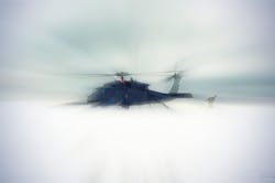
Landing a helicopter in choking dust or blinding snow can be particularly difficult because pilots can become disoriented easily near the ground as they lose view of the horizon and other visual cues.
Without help in these kinds of conditions, helicopter pilots can lose track of the horizon during critical moments in takeoff and landing. This can cause pilots to roll the aircraft while close the ground, which risks hitting the rotors on the ground or other nearby objects.
Sierra Nevada's degraded visual environment (DVE) avionics provide increased flight safety and operational capability by restoring pilot situational awareness in severe DVE. These sensor-agnostic, configurable systems use input from several different passive and active high-resolution and deep-penetrating sensors to provide real-time, multi-sensor fused imagery and command guidance symbology throughout, company officials say. Sierra Nevada makes DVE equipment for fixed-wing aircraft and helicopters.
In 2016 Sierra Nevada demonstrated advancements in the company's synthetic vision technology during demonstrations at Flight Trials in Yuma, Ariz., as part of the military DVE Mitigation (DVE-M) program -- a multi-year U.S. Army research effort to test sensor, flight control, and cueing technology combinations on the ground and in the air to provide helicopter pilots with visual awareness in DVE environments.
For the DVE-M program, Sierra Nevada engineers focused on real-time fusion of multi-sensor data from millimeter wave radar, light detection and ranging (LIDAR) sensors, infrared cameras, and various a-priori digital terrain data, company officials say.
Related: DARPA launches Sandblaster helicopter avionics program
During the Yuma demonstrations, Sierra Nevada’s DVE technology enabled pilots to conduct more than 86 safe approaches to hover and landing in dust and heavy brownout conditions.
story continues below
In early 2017 Sierra Nevada demonstrated the company's DVE technology at the European NATO DVE Flight Trials, focusing on additional degraded visual conditions involving fog, rain, sand, and snow.
In mid-2013 the Aviation Applied Technology Directorate of the Army Research, Development, and Engineering Command at Fort Eustis, Va., awarded a contract to Sierra Nevada to integrate and test the company's Helicopter Autonomous Landing System (HALS) aboard an Army UH-60A/L helicopter as part of the AMRDEC DVE-M program.
The Sierra Nevada HALS helicopter avionics uses a 3D image-rendering 94 GHz pulsed radar, global positioning system (GPS), inertial sensors, and cockpit displays to help helicopter pilots view geographic features outside the aircraft during brownouts and whiteouts from dust, snow, or other visual impairments.
The HALS system uses radar data translated to color graphic representations on cockpit displays to help helicopter pilots control the aircraft's roll, pitch, and yaw based on radar-generated graphic representations of the ground and nearby geographic features in zero-visibility conditions.
HALS avionics enables helicopter pilots to take off, land, and fly in all degraded visual conditions, provides visual situational awareness to enable pilots to see and avoid wires, cables, and terrain, and well as follow landmarks in poor visibility.
The system also included Brownout Symbology Software (BOSS), precise guidance to landing in zero visibility, and safe transition from visual to instrument flying conditions.
On last week's contract Sierra Nevada will do the work in Sparks, Nev., and should be finished by May 2024. For more information contact Sierra Nevada Corp. online at www.sncorp.com, or the Air Force Materiel Command-Robins Air Force Base at www.robins.af.mil.
About the Author
John Keller
Editor-in-Chief
John Keller is the Editor-in-Chief, Military & Aerospace Electronics Magazine--provides extensive coverage and analysis of enabling electronics and optoelectronic technologies in military, space and commercial aviation applications. John has been a member of the Military & Aerospace Electronics staff since 1989 and chief editor since 1995.
Voice Your Opinion!
To join the conversation, and become an exclusive member of Military Aerospace, create an account today!

Leaders relevant to this article: