Sensor payloads for unmanned vehicles

Designers of unmanned vehicles are using a variety of electro-optical and radar sensors to provide unprecedented reconnaissance and surveillance capabilities for deployed military forces.
A growing number of unmanned vehicles — in the air, on the ground, and at sea — represent a vast universe of sensors and sensor processing that, combined, could provide some of the most detailed intelligence information to U.S. and allied military forces.
Some of the chief enabling technologies for this new generation of connected unmanned vehicle sensor payloads include electro-optical sensors like infrared sensors, visible-light cameras, multispectral, and hyperspectral sensors.
Also important are small power-efficient radar systems suitable for unmanned vehicles, digital signal processing to make sense of sensor information and pull out relevant information for battlefield commanders, and sophisticated networking to blend information from many different unmanned sensor payloads to provide a rich information picture for battlefield commanders.
One prominent company involved in electro-optical unmanned vehicle sensor payloads is FLIR Systems in Wilsonville, Ore. FLIR has introduced the UltraForce 275-HD compact multi-sensor gyro-stabilized surveillance system for weight, power and footprint-constrained platforms like unmanned aerial vehicles (UAVs). The gimbal weighs slightly more than 33 pounds.
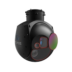
Octopus ISR Systems in Riga, Latvia, offers the Epsilon 175 small gyro-stabilized electro-optical four-sensor payload for UAVs for military applications, order control, and civil uses.
Electro-optical sensors
This sensor payload has applications in military surveillance and reconnaissance, as well as counter-drug operations, homeland security, and search and rescue. The sensor package has a continuous-zoom 3-to-5-micron thermal imager with 640-by-512-pixel resolution, high-definition color camera with low-light functionality for dawn-to-dusk use, four-axis active stabilization, and options for laser range finders.
The system also comes with backlit and night vision goggle-compatible remote controller with integrated multi-mode auto-tracker to track moving or stationary targets.
Two years ago FLIR introduced the Star SAFIRE 380-HLDc airborne thermal imaging system for use on manned and unmanned aircraft. It offers multispectral imagers with precision laser designation in a relatively small size, weight, and power consuming (SWaP) package. The high-definition electro-optical and infrared targeting system has a 1280-by-720-pixel indium antimonide medium-wave infrared focal plane array, with 40-to-1-degree continuous zoom
The Star SAFIRE 380-HLDc also has a charge coupled device (CCD) high-definition color visible-light camera with 1280-by-720-pixel resolution, as well as an optional indium gallium arsenide shortwave infrared camera with 720-by-1080-pixel resolution and 33-to-0.28-degree fields of view. It has four-axis stabilization with digital inertial measurement unit and Global Positioning System receiver for geo-pointing and target geo-location capability.
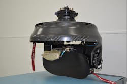
Another electro-optical sensor supplier for UAVs is Hood Tech Vision Inc. in Hood River, Ore. Hood Tech offers the SWaP-optimized Alticam 05EO5 gimbal turret imaging payload for small UAVs. The gimbal turret system offers pan-over-tilt imaging system has low-power video that uses less than 20 Watts of power and weighs less than two pounds.

IMSAR LLC in Springville, Utah, offers the NSP-5 ER radar for UAVs, which provides resolution ranging from very fine to 10 meters, and can detect large targets at sea from as far away as 62 miles.
This small design offers extra space and power aboard the aircraft for several additional intelligence sensors and on-board digital signal processing, company officials say. The four-axis gyro-stabilized gimbal includes embedded video stabilization and tracking with an embedded video server and optional network interface.
Dual-mode operation provides network, serial, or analog video. The sensor turret is isolated from vibration, and can serve as a drop-in replacement for earlier Alticam 06 and Alticam 07 turret models.
Octopus ISR Systems in Riga, Latvia, offers the Epsilon 175 small gyro-stabilized electro-optical four-sensor payload for UAVs, which weighs 5.7 pounds, and measures 6.8 by 8.1 inches. The medium wave infrared (MWIR) gimbal has a 30x optical zoom electro-optical (EO) sensor, 15x optical zoom MWIR sensor, laser range finder, and laser illuminator, this gimbal is an ideal choice for unmanned aerial vehicles (UAV) used for border control, military purposes, and a variety of civil applications.
Its infrared sensor uses a 3-to-5 micron cooled staring array, has an 18-to-275-millimeter 15x zoom lens with a 24.5-by-1.5-degree vertical field of view, 640-by-512-pixel resolution, and runs at 30 frames per second.
The Epsilon 175 decreases the weight of the sensor payload, which increases UAV endurance to enable longer missions or more spare capacity for other equipment, Octopus officials say.
The UAV sensor payload operates in temperatures from -40 to 50 degrees Celsius; offers 360 degrees of continuous pan, as well as -90 degrees to 30 degrees elevation; a slew rate of 120 degrees per second, and typically uses 35 Watts of power.
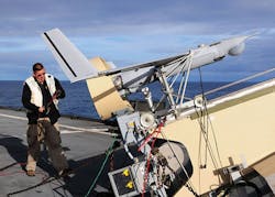
Hood Tech Vision in Hood River, Ore., provides the SWaP-optimized Alticam 05EO5 gimbal turret imaging payload for small UAVs like the military ScanEagle.
Radar for unmanned systems
Electro-optical sensors aren’t the only kinds of for unmanned vehicles. Radar systems are becoming available for large- and medium-sized UAVs for surveillance, as well as for sense-and-avoid applications for UAVs operating in controlled airspace.
Fortem Technologies Inc. in Pleasant Grove, Utah, earlier this year introduced the TrueView R20 drone radar, a compact, high-performance detect-and-avoid radar to help UAVs detect and prevent potential air-to-air collisions and navigate safely beyond-visual-line-of-sight day or night and in clouds, fog, smog, and other challenging weather conditions.
Using artificial intelligence (AI) algorithms, TrueView provides situational awareness for safe unmanned aircraft operations. The system weighs 1.5 pounds.
Another UAV radar supplier is IMSAR LLC in Springville, Utah, which specializes in small radar systems, digital signal processing, radar, manufacturing, and inertial measurement systems. The NSP-5 ER from IMSAR provides radar resolution ranging from very fine to 10 meters, and can detect large targets at sea from as far away as 62 miles. Its typical radar range is about 27 miles at 1-meter resolution. This UAV radar is shorter than 5 feet, is 5.5 inches in diameter, 8.5 inches high, and weighs 24 pounds.
IMSAR also provides the NanoSAR B UAV radar, which measures 6.2 by 7.2 by 4.5 inches, weighs 3.5 pounds, and transmits 1 Watt of power. On board firmware compresses real-time SAR data and transmits it to a ground station that generates and archives the imagery. The system operates day or night, in rain, snow, fog, dust, or smoke.
IMSAR also provides the NanoSAR C for detection, location, and classification of targets. The unit measures 5.5 by 3.5 by 2 inches, weighs 2.6 pounds, and transmits 1 Watt of power. NanoSAR C provides detailed real-time aerial radar images from a payload small and light enough to be mounted in a Tier I or II UAV.
General Atomics Aeronautical Systems in Poway, Calif., builds the Lynx synthetic aperture radar to provide the MQ-9 Reaper UAV with high-resolution photographic-quality radar imagery through clouds, rain, dust, smoke, and fog.
NanoSAR C is integrated with IMSAR’s Lisa ground station and Viper communication link, and operates day or night, in rain, snow, fog, dust, or smoke. Its radar, turret, antenna, and cabling total less than 86 cubic inches, and can mount in a 7-inch-diameter wing-mounted pod, or inside the aircraft fuselage.
Four years ago IMSAR won a $99 million contract from the U.S. Army’s Natick Soldier System Center (NSSC) in Natick, Mass., to develop synthetic aperture radar (SAR) systems for UAVs.
Another UAV radar provider is UAV designer is General Atomics Aeronautical Systems segment in Poway, Calif. General Atomics builds the Lynx synthetic aperture radar for the MQ-9 Reaper hunter-killer drone.
The Lynx multi-mode radar provides high-resolution, photographic-quality radar imagery through clouds, rain, dust, smoke, and fog. The radar consumes minimal Size, Weight, and Power (SWAP) while delivering precision air-to-surface targeting accuracy and superb wide-area search capabilities, General Atomics officials say.
Lynx features SAR, ground/dismount moving target indicator (GMTI/DMTI), and maritime wide area search (MWAS) modes. Lynx’s search modes provide the wide-area coverage and allow for cross-cue to a narrow field-of-view (FOV) electro-optical/infrared (EO/IR) sensor.
Lynx includes two spotlights and two strip map SAR modes. Spotlight mode produces high-resolution imagery on a defined point. Strip map mode mosaics several spot SAR images together to form one large image.
SAR imagery can help detect subtle changes in a scene by overlaying two images taken at different times. Coherent change detection (CCD), amplitude change detection (ACD), and automated man-made object detection (AMMOD) algorithms rapidly highlight the differences between the first and second SAR image for analysis.
Fortem Technologies Inc. in Pleasant Grove, Utah, has introduced the TrueView R20 drone radar, a compact, high-performance detect-and-avoid radar to help UAVs detect and prevent potential air-to-air collisions and navigate safely in clouds, fog, smog, and other challenging weather conditions.
The GMTI mode helps locate moving vehicles, while DMTI enables operators to detect very slow-moving vehicles and people on foot. In addition, operators can select a GMTI/DMTI target and automatically cross-cue to the EO/IR sensor in narrow FOV for visual identification of the target.
Lynx’s maritime mode detects ship and boat traffic in various sea states; it also integrates automated identification system (AIS) information for target correlation and identification. MWAS is suitable for coastal surveillance, drug interdiction, long-range surveillance, small target detection, and search and rescue operations.
Special-purpose sensor payloads
In addition to general-purpose surveillance sensors, some companies are building specialized electro-optical unmanned sensor payloads for specific military jobs. Multispectral UAV sensor payloads at Arete Associates in Tucson, Ariz., are designing a system to help military unmanned helicopters detect and pinpoint mines and obstacles in beach surf zones to help keep U.S. Marines safe during amphibious attacks.
The sensor payload is called the AN/DVS-1 Coastal Battlefield Reconnaissance and Analysis (COBRA) block 1, which supports the Navy Littoral Combat Ship (LCS) mine-countermeasures mission. Carried on the Navy Northrop Grumman MQ-8B Fire Scout unmanned helicopter, the sensor system surveys the surf zone and beach zone to detect and localize mine fields and obstacles prior to amphibious assault.
The AN/DVS-1 COBRA passive multispectral sensor system offers off-board processing and includes stabilized step stare digital gimbal, high-resolution multispectral imaging digital camera with spinning six-color filter wheel, a processing unit, and a solid-state data storage unit.
The gimbal is about 19 inches long and 11 inches in diameter, and collects six different color-band images across a large area using a step-stare pattern. At the mission, personnel load its data storage unit into a post mission analysis station.
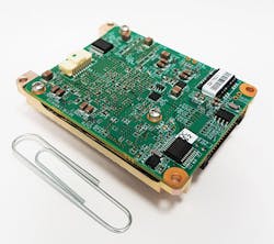
Commtact Ltd. in Yavne, Israel, offers the Mini-Micro Data Link System (M2DLS) digital data link system for micro size platforms like unmanned vehicles.
The COBRA Block I system has two airborne payloads, the post mission analysis station, and the tactical control system segment for the UAV ground control station to plan the flight tracks for the COBRA mission, monitor the mission, and reprogram the flight path if necessary.
COBRA began as a U.S. Marine Corps advanced technology program in the 1990s. The system uses incremental development, with three initial blocks of development planned with each introducing new or enhanced capabilities. COBRA Blocks II and III are in concept refinement and technology development.
Unmanned sensor networking
Just as important as gathering sensor information from unmanned vehicles is the ability to network sensors to blend information and bring this information quickly to the fighting forces that need it. Commtact Ltd. in Yavne, Israel, offers the open-architecture Mini-Micro Data Link System (M2DLS) combined digital data link system for micro size platforms like unmanned vehicles and sensors.
The device also is for other applications that are sensitive to size, weight, and power consumption (SWaP). The M2DLS is available as an airborne and ground data terminal.
The M2DLS It measures 6 by 5 by 2 centimeters and weighs 60 grams, making it suitable for small unmanned ground vehicles, small vertical-takeoff unmanned aerial vehicles, sensors, and related applications. The M2DLS can download real-time video images, LAN, serial data, and information from most available sensors.
It supports as many as six antennas simultaneously for multi-coverage support. It offers power transmission varying from 0.25 to 1 Watt, and enables full duplex wideband with cyber security protection, digital link, error correction techniques, and high-rate communication in the uplink and downlink channels.
