Q-CTRL demonstrates GPS-free maritime navigation using quantum gravity sensing
Key Highlights
- Q-CTRL's maritime navigation system uses quantum gravimeters to measure Earth's gravity variations and determine vessel position without relying on GPS signals.
- During trials, the navigation technology achieved an accuracy within one nautical mile in the Coral Sea, demonstrating its potential for maritime use.
- Gravity-based navigation offers a resilient alternative to GPS, especially in environments where signals are jammed or spoofed.
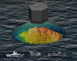
SYDNEY — Q-CTRL in Sydney, Australia, has demonstrated a maritime navigation system that uses measurements of Earth's gravity to determine a vessel's position without GPS.
During trials in the Coral Sea off Australia's east coast, the company used a quantum gravimeter aboard a vessel to measure variations in the local gravitational field. The system compared those measurements with existing gravity maps to estimate the vessel's location.
Q-CTRL says the system navigated without GPS and achieved positioning accuracy within one nautical mile during the trials. The demonstration expands the company's Ironstone Opal navigation technology into the maritime environment. The system is designed to provide an independent source of positioning information when satellite navigation is unavailable.
Gravity provides another reference for navigation
GPS gives a receiver its position using signals transmitted by satellites. Gravity-based navigation takes a different approach because it does not depend on an external radio-frequency signal.
Earth's gravitational field is not exactly uniform. Differences in geology and other physical characteristics create small variations from one location to another. A sufficiently sensitive gravimeter can measure those changes as a vessel moves.
Because the sensor observes a naturally occurring physical property rather than receiving a navigation signal, the gravity measurement itself does not depend on GNSS transmissions that an adversary could jam or spoof.
The technique can also complement an inertial navigation system. Inertial sensors can track a vehicle's movement without external signals, but small measurement errors add up over time and cause the calculated position to drift. An independent position reference can provide corrections as that error grows.
Quantum sensors have to work outside the laboratory
Measuring gravity closely enough for navigation presents another engineering problem. Quantum sensors can make highly sensitive measurements, but equipment that performs well under controlled laboratory conditions also has to contend with motion, vibration and environmental changes aboard an operating vessel.
Q-CTRL describes its approach as software-ruggedized quantum sensing. This means that instead of relying entirely on additional mechanical systems to isolate the sensor from its surroundings, the company uses software to stabilize its measurements under changing conditions.
During the Coral Sea trials, Q-CTRL installed the gravimeter in a passenger cabin rather than using a dedicated stabilized platform. The company says the system operated autonomously without temperature control, gyroscopic motion stabilization or periodic recalibration.
Those conditions allowed Q-CTRL to test whether the sensor could continue extracting useful gravity measurements while the vessel experienced movement at sea.
Gravity maps turn measurements into position
A gravimeter alone does not tell a vessel where it is, though. The navigation system also needs a reference that connects measured gravitational variations with geographic locations. Q-CTRL's system uses existing gravity maps for that purpose. As the vessel travels, the sensor measures changes in gravity and the software searches for corresponding features in the mapped gravitational field.
The company calls the approach GravNav. It follows a similar principle to Q-CTRL's magnetic navigation, or MagNav, technology, which uses variations in Earth's magnetic field as a position reference.
The two methods rely on different geophysical measurements. Q-CTRL says gravity mapping is particularly suited to maritime navigation because of the availability of gravity data over the ocean.
GPS denial is driving interest in independent navigation
The ability to navigate without satellite signals has taken on greater importance as GPS and other GNSS systems face deliberate interference.
Jamming overwhelms satellite navigation signals and can prevent a receiver from calculating a usable position. Spoofing instead introduces false signals that can cause a receiver to calculate an incorrect location.
Alternative navigation technologies give vehicles another source of positioning information when those signals become unreliable. Different approaches can use inertial sensors, terrain, magnetic fields, celestial references or other environmental measurements depending on the vehicle and operating environment.
Q-CTRL previously demonstrated its Ironstone Opal magnetic-navigation technology during ground and airborne trials in 2025. The new maritime tests extend the company's work to gravity-based positioning at sea.
The company is also working with defense organizations on quantum sensing and computing, including the U.S. Defense Advanced Research Projects Agency, Defense Innovation Unit, Australian Department of Defence and UK Royal Navy.
About the Author
Samantha McGrail
Associate Editor
Related
Voice Your Opinion!
To join the conversation, and become an exclusive member of Military Aerospace, create an account today!
 Leaders Logo
Leaders relevant to this article: