Areté to build lidar sensor for uncrewed aircraft to automate underwater mine, hazard, and target detection
ARLINGTON, Va. – U.S. Navy researchers needed an experimental airborne sensor to provide small tactical uncrewed aerial vehicles (UAVs) with capabilities for mine countermeasures, uncrewed underwater vehicle (UUV) detection, and other target detection. They found their solution from Areté Associates in Northridge, Calif.
Officials of the Office of Naval Research (ONR) in Arlington, Va., announced a $15.4 million contract to Areté on Thursday for the or the Pushbroom Imaging LiDAR for Littoral Surveillance (PILLS) system.
PILLS is a compact lightweight light detection and ranging (lidar) system for precision bathymetry and topography suitable for operation from a small tactical uncrewed aerial vehicle.
This contract calls for Areté engineers to extend, adapt, and optimize the PILLS sensor, as well as its signal-processing and data-fusion algorithms to address additional future Navy capabilities like bathymetric survey and charting, underwater target detection, underwater hazard detection and avoidance, and lidar multi-mode sensing.
Related: Army searches industry for state-of-the-art imaging LIDAR for tactical mapping from UAVs
PILLS is a lightweight, low power, expeditionary sensor that enables high-resolution and accurate topographic and bathymetric maps from manned and uncrewed aircraft to greater depths than commercially available legacy systems.
PILLS provides precision hydrographic and terrain mapping for a variety of uncrewed vehicles. It has no moving parts, and eliminates the weight, size, power, and reliability issues of scanning lidar systems and cooled lasers.
PILLS is an order of magnitude smaller, lighter, and requires a fraction of the power of current lidar systems on manned aircraft, while delivering comparable mapping performance from a small UAV, company officials say.
Related: BAE Systems to develop airborne mine-hunting LIDAR for manned and unmanned aircraft
The system integrates a dedicated real-time kinematic GPS for precise mapping, independent of aircraft systems. PILLS requires a fraction of the power of current lidar systems on manned aircraft, and delivers comparable mapping performance from a small UAV.
Areté engineers have enhanced the PILLS sensor to operate in high shock and vibration typical of ship-launched and recovery uncrewed aerial vehicles in previous government Small Business Innovation Research (SBIR) research grants.
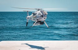
Schiebel Aircraft GmbH in Vienna and Areté demonstrated PILLS aboard the Schiebel CAMCOPTER S-100 UAV for the Office of Naval Research last summer.
Schiebel’s CAMCOPTER S-100 us a vertical takeoff and landing (VTOL) UAV that needs no prepared area or supporting launch or recovery equipment. It operates day and night and in bad weather to a range of 125 miles on land and at sea.
The S-100 navigates automatically via pre-programmed GPS waypoints or can be operated directly with a pilot control unit. Missions are planned and controlled via a simple point-and-click graphical user interface. High-definition payload imagery flows to the control station in real-time.
On this contract Areté will do the work in Tucson, Ariz., and Vienna, Austria, and should be finished by March 2027. For more information contact Areté Associates online at https://arete.com, Schiebel Aircraft at https://schiebel.net, or the Office of Naval Research at www.onr.navy.mil.
About the Author
John Keller
Editor-in-Chief
John Keller is the Editor-in-Chief, Military & Aerospace Electronics Magazine--provides extensive coverage and analysis of enabling electronics and optoelectronic technologies in military, space and commercial aviation applications. John has been a member of the Military & Aerospace Electronics staff since 1989 and chief editor since 1995.
