What does lidar measure and how does it create a 3D map?
Key Highlights
- Lidar transmits laser pulses and measures the time for reflections to determine distances to objects.
- The technology builds 3D point clouds by combining distance data with laser direction, creating detailed environmental maps.
- Lidar functions effectively in low-light conditions since it supplies its own illumination, unlike traditional cameras.
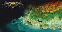
NASHUA, N.H. — Lidar stands for light detection and ranging. At its most basic, it answers the question about how far away something is. A single measurement can provide the distance to one point on an object or surface. Repeat that process thousands or millions of times across an area, and those individual distance measurements can form a three-dimensional representation of the environment.
That ability makes lidar useful across aerospace applications. Aircraft can use it to measure terrain, while autonomous vehicles and spacecraft can use it to detect obstacles and map their surroundings. Understanding how that works starts with a pulse of light.
Related: Phlux launches 200 µm APD receiver module for lidar and defense applications
How does lidar measure distance?
A lidar system transmits laser light toward a target and detects the light that reflects back toward the sensor. The system measures the time between sending the light and receiving its return. Because light travels at a known speed, the sensor can use that elapsed time to calculate the distance between itself and the object.
The light makes a round trip. It travels from the lidar to the target and then back to the lidar, so the distance calculation accounts for both parts of the journey. In simplified terms, the system multiplies the travel time by the speed of light and divides the result by two.
Those times are extremely short. Light travels about 300,000 kilometers per second in a vacuum, so the electronics must measure very small time intervals accurately.
How does lidar turn distance measurements into a 3D view?
A lidar system directs its laser toward different points in its surroundings. For each return, the system combines the measured distance with the direction of the laser to determine where that point sits relative to the sensor.
As the process repeats, the measurements build what engineers call a point cloud. Each point represents a location where laser light encountered a surface and returned to the sensor.
So, imagine scanning a large rock. One laser return might measure a point on its front face. Another might hit its upper edge. Others might strike the ground around it. Taken individually, those measurements provide limited information. Together, they begin to show the rock's size, shape and position relative to the sensor.
Does lidar need sunlight to work?
A conventional camera collects light from the scene around it, so the quality of its image can depend heavily on illumination. Lidar, on the other hand, supplies the light it uses to make a measurement. It actively sends laser light toward the environment and looks for the returning signal.
That distinction can make lidar useful in places where available light changes or is limited, but it does not mean environmental conditions do not affect lidar. The amount of laser light that returns to the sensor can depend on the target's distance, surface properties and angle. In terrestrial applications, atmospheric conditions can also affect the path between the sensor and its target.
So, engineers have to consider more than whether a laser pulse reaches an object. The system must also detect and interpret the return reliably enough to produce useful measurements.
What determines how much detail lidar can capture?
Not every lidar produces the same view of its surroundings. How a system scans the environment affects where it collects measurements and how closely those measurements sit together. More measurements across a surface can provide a denser representation of its shape, while fewer measurements may leave larger gaps between points.
Range also matters. A system designed to detect objects hundreds of meters away faces different requirements than one that examines nearby surfaces.
The sensor's field of view determines how much of the surrounding area it can cover. Its scanning pattern determines where it looks within that field. Engineers can balance those characteristics against requirements for size, weight, power, range and update rate.
That becomes particularly important on aircraft and spacecraft, where sensing equipment competes with other systems for limited space, mass and electrical power.
How can a vehicle use lidar measurements?
A 3D point cloud can provide information that a vehicle's onboard systems can use. Perception software, for example, can analyze lidar measurements to locate obstacles. Navigation software can then combine that information with measurements from cameras, inertial sensors or other equipment to help determine a path. The distinction is important. Lidar measures distance, but it does not navigate a vehicle by itself.
For an autonomous rover, lidar may detect the shape and distance of terrain ahead. Other onboard systems determine what those measurements mean, whether the terrain presents a hazard and how the vehicle should respond.
The same basic sequence applies whether lidar is looking across a road, toward an aircraft or over the lunar surface. It transmits light, measures its return, calculates distance and repeats the process.
About the Author
Samantha McGrail
Associate Editor
Related
Voice Your Opinion!
To join the conversation, and become an exclusive member of Military Aerospace, create an account today!
 Leaders Logo
Leaders relevant to this article: