How do counter-drone systems operate when GPS is jammed?
Key Highlights
- Inertial navigation systems use gyroscopes and accelerometers to measure a platform's movement without relying on satellite signals.
- Fiber-optic gyroscopes detect rotation by measuring light behavior inside optical fibers, offering high accuracy without mechanical parts.
- These systems help counter-drone stations distinguish between target movement and platform motion, improving tracking and engagement precision.
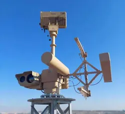
NASHUA, N.H. — A counter-drone station needs to know where an incoming aircraft is flying and where its own sensors and weapons are pointing. This becomes more difficult when the station is mounted on a moving vehicle or operating in an area where electronic warfare interferes with satellite navigation.
GPS can provide position and timing information, but a counter-drone system cannot assume those signals will always be available or trustworthy. Inertial navigation provides another way to measure movement and orientation. It uses sensors carried by the platform itself rather than depending on signals transmitted from satellites.
Advanced Navigation’s recent agreement to supply Boreas inertial navigation systems for KONGSBERG’s PROTECTOR counter-drone platforms illustrates where that capability fits into air defense. While the navigation equipment does not replace the station’s threat-detection sensors or fire-control system, it provides information about the station’s own motion and orientation that those systems can use.
Related: SPARC AI launches network-based GPS-denied drone positioning service
Why a counter-drone station needs to know its own orientation
A sensor may detect a drone and determine its direction relative to the sensor. To turn that observation into a useful track, the counter-drone system also needs to account for how its own platform is positioned.
Consider a station mounted on a vehicle. If the vehicle turns, pitches or rolls, the direction its sensor faces changes even if the drone continues along the same path. The system must distinguish movement of the target from movement of the platform carrying the sensor.
That distinction also matters when the station directs a weapon toward a tracked object. Sensor measurements, platform orientation and fire-control calculations must refer to a consistent understanding of where the equipment is pointing.
An inertial navigation system provides the orientation measurements that help the station account for its own movement.
What happens when GPS becomes unreliable?
Satellite navigation receivers estimate position using signals transmitted from orbit. Those signals can be disrupted by jamming or manipulated through spoofing, which attempts to make a receiver calculate an incorrect position or time.
A counter-drone platform that depends on satellite navigation may then lose a useful external reference or receive information it cannot trust.
Inertial navigation works differently. Gyroscopes measure angular motion, while accelerometers measure linear acceleration. Navigation software combines those measurements to estimate changes in orientation, velocity and position.
Because the sensors measure the platform’s motion directly, they can continue producing navigation information without receiving GPS signals.
This does not mean an inertial system can maintain perfect accuracy indefinitely. Small sensor errors accumulate as the system calculates movement over time. External updates can help correct that drift when trustworthy references are available.
How fiber-optic gyroscopes measure rotation
Advanced Navigation’s Boreas system uses fiber-optic gyroscopes, which measure angular rotation through the behavior of light traveling inside a coil of optical fiber. Light travels in opposite directions around the fiber path. When the gyroscope rotates, the two beams experience a measurable difference associated with that motion. The instrument uses the difference to calculate angular rate.
Unlike a traditional mechanical gyroscope, a fiber-optic gyroscope does not need a spinning rotor to measure rotation. A navigation system combines measurements from gyroscopes and accelerometers to estimate how the platform moves in three dimensions. Its software can also incorporate other available sensor inputs to improve the resulting navigation estimate.
Navigation accuracy is only one part of an engagement
A counter-drone system must detect an aerial target, maintain a track, determine how to respond and direct the appropriate equipment before it can engage the target.
Inertial navigation supports that process, but it does not perform all those functions on its own. A gyroscope cannot identify a drone, and an inertial navigation system cannot establish whether a tracked object should be engaged. The quality of the overall result depends on the station’s sensors, navigation equipment and fire-control system working together.
What inertial navigation can and cannot solve
An inertial navigation system can continue measuring motion during a GPS outage, but it cannot prevent every problem caused by electronic warfare. Jamming may affect other radio-frequency equipment, and spoofing may complicate the use of external updates if a system cannot determine which inputs are trustworthy.
The navigation system also remains subject to its own sensor errors and integration limits. Its performance depends on factors such as sensor quality, calibration, operating conditions and the length of time it must function without a reliable external reference.
About the Author
Samantha McGrail
Associate Editor
Related
Voice Your Opinion!
To join the conversation, and become an exclusive member of Military Aerospace, create an account today!
 Leaders Logo
Leaders relevant to this article: